Deep within the marshy embrace of Egypt’s Nile Delta, a silent city has spent millennia sinking into the earth. This is Buto, known today as Tell el-Fara’in, a place where the history of Egypt doesn’t just sit on the surface, but layers itself like the pages of a heavy, water-logged book. For centuries, the secrets of this ancient metropolis remained trapped under thick deposits of mud and the ruins of later civilizations. To reach the oldest chapters of Buto, which dates back as far as the Predynastic period in 3800 BCE, archaeologists have traditionally faced a grueling battle against time, money, and the rising groundwater that turns every trench into a muddy struggle.
But a team of researchers recently arrived at the site not just with shovels, but with eyes that can see through the earth itself. By testing a sophisticated suite of new technologies, they have managed to peel back the layers of the Nile Delta without moving a single stone, discovering what appears to be a monumental structure—a tomb or a temple—dating back roughly 2,600 years. Their success marks a turning point in how we hunt for the past, proving that the best way to find a needle in a haystack of history is to scan the stack from space before ever touching the ground.
The Eye in the Sky and the Pulse in the Earth
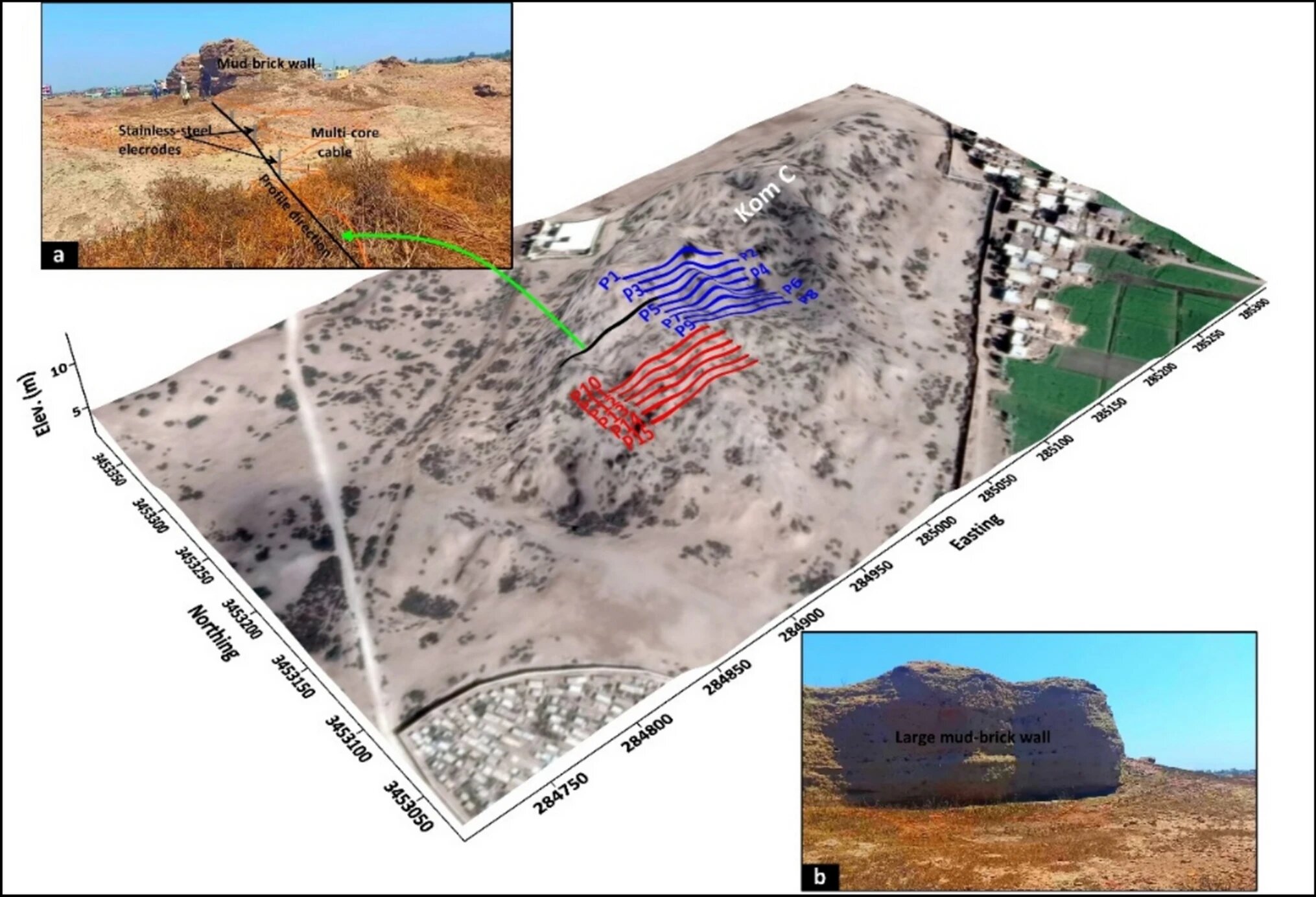
The hunt began far above the clouds. The researchers initiated their search using Sentinel-1, a satellite radar (SAR) system that monitors the Earth from orbit. By bouncing signals off the landscape, the satellite identified large-scale anomalies beneath the surface that the human eye could never detect. These digital shadows suggested that something massive was hiding under the silt, waiting to be rediscovered. However, a view from space can only provide a general map; to see the fine details, the team needed to get closer to the dirt.
Once the satellite flagged the areas of interest, the team deployed a technique known as electrical resistivity tomography (ERT). If the satellite was a bird’s-eye view, ERT functioned like an underground CT scan. The scientists placed a series of electrodes into the soil, sending electrical currents pulsing through the ground. Because different materials—like ancient stone, mudbrick, or loose soil—conduct or resist electricity in different ways, the team was able to translate those signals into a 3D model of what lay beneath their feet. This 3D inversion algorithm allowed them to “see” walls and chambers before a single person picked up a trowel.
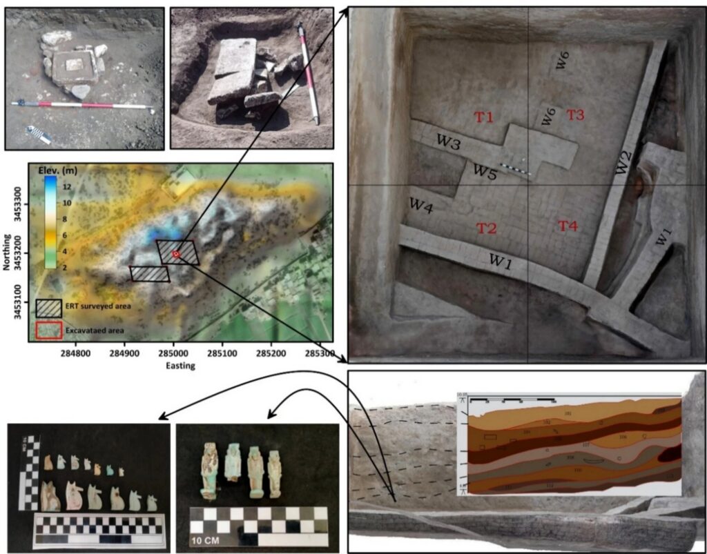
A Ghostly Architecture Emerges from the Deep
As the data from the ERT scans began to resolve, a hidden world took shape. In the shallowest layers, reaching down about three meters, the technology detected a chaotic jumble of broken pottery and debris. These were the remnants of the Roman and Ptolemaic periods, the younger layers of Buto that sat closest to the sun. But as the researchers looked deeper, between three and six meters below the surface, the scans revealed something far more organized and ancient.
Emerging from the digital noise was a large, well-defined structure belonging to the Saite period. This era, which flourished around 2,600 years ago, was a time of cultural revival in Egypt, and the structure detected by the sensors appeared to be of significant importance. The sharp lines and dense materials suggested the presence of a substantial tomb or perhaps a shrine. The accuracy of the technology was so precise that it delineated the exact footprints of mudbrick walls, providing a ghostly blueprint of a building that had been forgotten by humanity for over two millennia.
Proving the Vision with a Golden Discovery
To ensure their high-tech “X-ray” of the earth was accurate, the researchers moved from the digital realm back to the physical one. They launched a targeted, 10 x 10 meter excavation at the exact spot where the sensors predicted the structure would be. As the team carefully cleared the earth, the mud gave way to the very mudbrick walls the 3D models had promised. Along with the architecture, they uncovered a collection of religious artifacts, confirming that this was indeed a site of spiritual or funerary significance.
This small-scale dig was a triumph for the “integrated approach.” By combining remote sensing data with geophysical measurements, the team proved they could achieve a very accurate vision of buried settlements even in a region as geographically complex as the Nile Delta. The 3D inversion algorithms had done the heavy lifting, allowing the archaeologists to bypass the “blind digging” that often consumes years of research time. Instead of fighting the mud and the groundwater across a massive area, they could go straight to the heart of the mystery.
Why the Digital Shovel Matters for Our Past
The success at Buto is more than just the discovery of one Saite building; it is a proof of concept for the future of history. The researchers are already looking ahead, planning to return with even larger equipment designed to reach deeper, older levels of the city, potentially touching the very beginnings of Egyptian civilization in the Predynastic period. This methodology allows scientists to map entire buried settlements with surgical precision, protecting fragile remains from unnecessary disturbance while maximizing the information gained.
This research matters because it changes the stakes of archaeological discovery. In many parts of the world, ancient sites are buried under meters of sediment, modern cities, or rising water tables, making them nearly impossible to study through traditional means. By perfecting this multipronged technological approach, we can now map the footprint of human history across the globe without the risk and expense of massive excavations. We are entering an era where we can read the stories written in the soil before we even open the earth, ensuring that the legacy of places like Buto is preserved for generations to come.
Study Details
Mohamed A. R. Abouarab et al, Multi-scale detection of buried archaeological elements across different occupation phases: an integrated approach using radar satellite imagery and electric resistivity tomography at Buto, northwestern Nile Delta of Egypt, Acta Geophysica (2026). DOI: 10.1007/s11600-026-01809-4