Sweeping across the dense forests of southwestern Amazonia, airborne lasers exposed an archaeological landscape far larger than anyone had expected. What first appeared to be scattered ancient monuments has now expanded into evidence for a vast network of ceremonial earthworks spread across an area roughly three times larger than previously recognized, forcing researchers to rethink how many people once lived in one of Earth’s largest tropical forests and how deeply they reshaped it.
For decades, archaeologists studying southwestern Amazonia faced a simple but stubborn problem. The region’s dense tropical canopy concealed almost everything beneath it. Earthworks became visible mainly where modern deforestation had stripped away the trees, leaving only scattered clues about the people who built them.
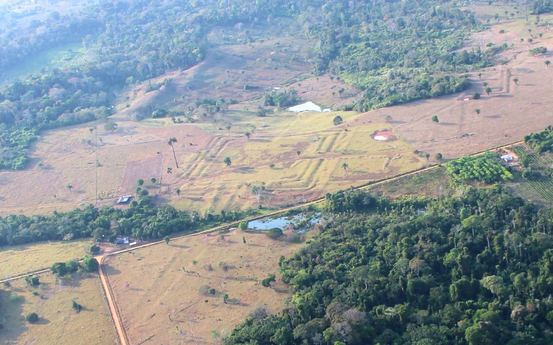
Those clues were already remarkable. More than 1,200 geometric earthworks had previously been documented from satellite imagery and aerial photographs across parts of Brazil. Many consisted of enormous ditches and embankments arranged in carefully planned geometric shapes. Researchers associated most of them with a precolonial society they call the Aquiry civilization, whose communities began constructing these monuments more than 2,500 years ago.
But the visible sites raised an unsettling question. If only cleared land could be examined easily, how many more monuments were still hidden beneath untouched rainforest?
To answer that question, researchers turned to a technology capable of looking through the forest itself.
Lasers peeled away the canopy without cutting a single tree
Instead of searching from the ground, the research team flew aircraft carrying airborne LiDAR—short for Light Detection and Ranging—over large stretches of the Amazon.
LiDAR works by sending laser pulses toward the ground. While many pulses bounce off leaves and branches, enough reach the surface to allow scientists to reconstruct the landscape beneath the forest. By digitally removing the vegetation, archaeologists can identify ancient earthworks that would otherwise remain invisible.
Between June and July 2024, aircraft surveyed 4,497 square kilometers along 10 flight lines extending across the Brazilian states of Acre and Amazonas.
The results immediately changed the picture.
Researchers documented 432 earthworks, including 396 that had never been identified before. Only 36 had already been known.
Even more surprising, many structures lacked the deep surrounding ditches that earlier satellite studies depended on for detection. Instead, LiDAR revealed numerous geometric embankments that had blended almost perfectly into the forested landscape.
The technology wasn’t merely finding additional examples—it was exposing entirely new categories of monumental architecture that had been largely overlooked.
Ancient ceremonial landscapes turned out to be far more complex
The newly mapped earthworks display striking variety.
Some are solitary geometric enclosures connected by roads. Others occur in clusters containing as many as eight linked structures. Individual monuments typically cover between 0.35 and 14 hectares, although the largest known example approaches 50 hectares.
The researchers argue that these were not ordinary villages or military fortifications.
Instead, multiple lines of archaeological evidence indicate that they functioned primarily as public ceremonial and political centers where people gathered for social, ritual, and communal activities rather than permanent residence.
Constructing features of this scale would have demanded substantial planning, organized labor, and sophisticated understanding of geometry. Maintaining them over roughly 1,500 years would also have required long-term social organization extending across generations.
Rather than isolated monuments scattered randomly through the forest, the earthworks appear to have formed parts of an extensive cultural landscape shared by communities connected through common traditions.
The civilization’s true footprint turned out to be much larger
The new LiDAR surveys also helped researchers redefine where this society actually lived.
Earlier estimates placed the Aquiry cultural area at around 60,000 square kilometers.
By combining newly detected earthworks with previous archaeological surveys and satellite observations, the researchers now estimate that the civilization occupied approximately 183,000 square kilometers—roughly three times larger than earlier reconstructions.
The surveys also helped clarify its boundaries.
Some regions that had been considered likely to contain hidden earthworks yielded none during LiDAR flights, while other areas showed concentrations extending farther than expected. Together, these observations allowed the team to outline a much more precise geographic range for the civilization, although they emphasize that uncertainty remains regarding its southeastern extent because archaeological work there is still limited.
LiDAR revealed that archaeologists had been seeing only a fraction of the monuments
Perhaps the study’s most striking methodological finding came from comparing LiDAR with conventional satellite searches.
Within one heavily studied region, researchers had previously identified 30 earthworks using satellite imagery.
LiDAR found 156.
In other words, laser mapping detected approximately five times as many monuments as satellite imagery alone had revealed, even in areas where forests had already been cleared.
That comparison fundamentally changed the researchers’ estimates.
Using this fivefold correction together with LiDAR sampling across both high-density and lower-density regions, they calculated that the Aquiry landscape may contain approximately 24,000 to 30,000 earthworks in total.
Even their most cautious estimate approaches previous predictions for the maximum number of precolonial earthworks across the entire Amazon Basin.
The researchers note, however, that LiDAR itself is not perfect. Dense vegetation sometimes prevented enough laser pulses from reaching the ground, meaning some monuments almost certainly remain undetected. Accounting for these limitations could push the total closer to the upper end of their estimates.
The biggest surprise may be how many people the landscape could have supported
Estimating ancient populations is notoriously difficult.
Rather than simply counting monuments, the researchers combined several independent sources of evidence.
They examined radiocarbon dates from 162 samples collected from 32 archaeological sites, allowing them to estimate when different earthworks were active.
They compared ceremonial centers with later mound villages built in the same region after about AD 1000, using those settlements to estimate how many people similar communities may have contained.
They also considered ethnographic evidence describing gathering spaces used by Indigenous communities living in the broader region.
Radiocarbon modeling indicates that the greatest overlap in earthwork use occurred between approximately AD 100 and AD 300.
The researchers estimate that during this period roughly 25% to 60% of Aquiry ceremonial earthworks were simultaneously active.
Applying their population estimates to the number of active ceremonial centers produces a regional population of approximately 1.25 million to 3 million people during this peak period.
After accounting for monuments that LiDAR may still have missed beneath dense canopy, the estimate could potentially rise to 1.6 million to 3.8 million.
The authors emphasize that these are estimates rather than direct counts, built from archaeological evidence, settlement comparisons, and statistical extrapolation rather than census records.
The discoveries reshape how the Amazon’s past is understood
The findings challenge older ideas that large areas of Amazonian upland forest supported only sparse populations before European contact.
According to the researchers, the Aquiry communities occupied one of the most nutrient-rich portions of Amazonian terra firme, or upland rainforest. Archaeological evidence from previous excavations indicates they cultivated crops including maize, squash, and likely manioc, sweet potato, beans, peanuts, and chili peppers. Plant remains also show extensive use of Brazil nuts and several palm species.
Rather than exhausting the forest, the researchers argue that these communities actively managed it. Earlier work has linked Amazonian earthworks with concentrations of domesticated and semi-domesticated trees, and the current study notes that many economically important species still occur around archaeological sites.
The researchers therefore propose that the civilization left lasting marks not only in earthworks but also in soils, forest composition, and biodiversity.
The story is still incomplete
Despite dramatically expanding the known archaeological landscape, the researchers acknowledge important uncertainties.
The southeastern limits of the Aquiry civilization remain unresolved because portions of Rondônia have not yet been studied in sufficient archaeological detail.
LiDAR also cannot guarantee complete detection beneath especially dense forest canopy, meaning additional monuments likely remain hidden.
Population estimates likewise depend on assumptions about how many people maintained individual ceremonial centers and how many sites were occupied simultaneously. Although the authors support these estimates using several independent lines of evidence, they recognize that alternative assumptions would produce different totals.
Even so, the study substantially changes the scale of what archaeologists now recognize in southwestern Amazonia.
Instead of scattered ceremonial monuments belonging to relatively small populations, the evidence points toward an enormous cultural landscape containing tens of thousands of monumental earthworks spread across nearly 183,000 square kilometers. If future LiDAR surveys uncover comparable archaeological landscapes elsewhere in Amazonia, the researchers argue that estimates of the region’s precolonial population—and its long-term influence on tropical forests, soils, biodiversity, and even aspects of climate modeling—may need to be reconsidered.
Publication details
Martti Pärssinen, Over 20,000 precolonial earthworks in the Southwest Amazonia, Nature (2026). DOI: 10.1038/s41586-026-10835-7. www.nature.com/articles/s41586-026-10835-7