In a groundbreaking discovery, researchers have unearthed what may be the world’s oldest three-dimensional map, located in the Paris Basin. Found within a quartzitic sandstone megaclast at the Ségognole 3 rock shelter, this map has led to fresh insights into how Paleolithic humans perceived and interacted with their environment. Published in the Oxford Journal of Archaeology, the study not only offers a glimpse into prehistoric artistry but also showcases the advanced knowledge and capabilities of early humans, particularly regarding the manipulation of landscapes for practical and possibly spiritual purposes.
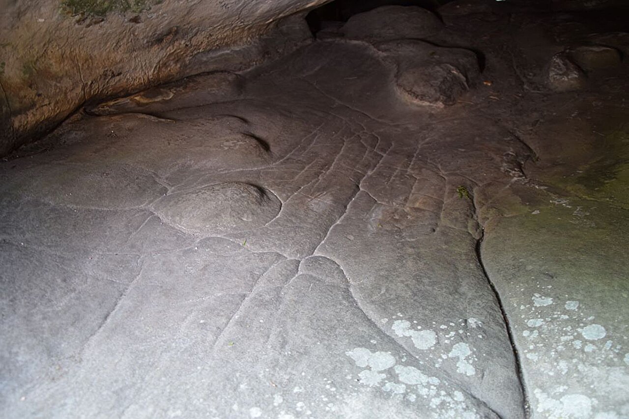
The Ségognole 3 rock shelter has long been known for its artistic engravings. Discovered in the 1980s, it features intricate depictions of two horses on either side of a female pubic figure, all carved in a distinctive Late Paleolithic style. However, the new research uncovers something far more profound within the same shelter: a miniature, three-dimensional representation of the surrounding landscape that has never been seen before.
A Collaboration of Disciplines
The research was led by Dr. Médard Thiry, a geoscientist from the Mines Paris—PSL Center of Geosciences, with key contributions from Dr. Anthony Milnes, a physicist at the University of Adelaide. Thiry’s fascination with the Ségognole 3 rock shelter began with a visit in 2017, when he noticed strange markings on the sandstone that appeared intentional, suggesting that early humans might have shaped the stone in ways that could influence its interaction with natural water systems.
Through years of study and observation, Thiry’s hypotheses were refined. He proposed that the Paleolithic inhabitants of this site had intentionally manipulated the landscape, modifying the shelter’s sandstone in a way that mirrored the human form—a theory he later verified through a combination of geological and archaeological analysis.
“I established in my earlier research that Paleolithic people had deliberately ‘worked’ the sandstone to mirror a female figure,” said Thiry. “This shaping included the deliberate opening of fractures that allowed water to infiltrate the stone, nourished by a consistent outflow at the base of what I call the pelvic triangle. But this was only the beginning.”
The Landscape as a Living Entity
Building on Thiry’s initial findings, Milnes and Thiry together uncovered something even more remarkable—what appears to be a three-dimensional miniature map of the surrounding landscape, dating to approximately 13,000 years ago. The study points to intentional geomorphological features crafted by early humans, reflecting a thorough understanding of local water flows, valleys, and the interconnectivity of natural resources.
Unlike modern maps, which show precise measurements and are used for navigation, this ancient representation does not depict distance, direction, or travel times. Instead, it provides a conceptual model of how the landscape functioned—focusing on the interaction of water flows, the convergence of valleys, and the formation of lakes and swamps downstream. Dr. Milnes elaborates, saying, “What we’ve described isn’t a map in the traditional sense. Instead, it’s a three-dimensional depiction of the functioning of the landscape, detailing natural water courses and other hydrological features, suggesting a sophisticated awareness of the environment by its makers.”
For Paleolithic humans, understanding the direction of water flow—its importance to survival and the local ecosystem—was far more crucial than what we think of today as geographical knowledge. These insights reflect a deep understanding of hydrological systems, one which would have had immediate relevance in daily life, especially in terms of finding freshwater sources and sustaining crops, if early humans had begun agricultural practices in this period.
Sculpting the Natural World
A crucial aspect of the new research was understanding how humans sculpted the environment to model natural water flows. This discovery challenges our previous notions of prehistoric technology and ingenuity. Through precise analysis of sandstone features, Dr. Thiry and his team observed that Paleolithic people had adapted the natural stone in a way that promoted the infiltration and redirection of rainwater, a feat previously unexplored in archaeological studies.
Thiry suggests, “Paleolithic humans meticulously shaped the sandstone to create specific flow paths for rainwater. This manipulation of natural features directly affected how water infiltrated the rock shelter and its immediate surroundings. No previous archaeological research had recognized these kinds of detailed hydraulic modifications.”
The presence of what could be described as “fittings” for water flow is key to understanding the shelter’s function. These intricate alterations were not merely artistic; they seem to represent both a practical and possibly symbolic connection to water. They point to a profound cultural and spiritual meaning of water, with Thiry suggesting, “These hydraulic installations, found near symbolic sexual figurations and a miniature landscape depiction, are likely to represent a deeper metaphysical understanding. Perhaps these installations reflected beliefs about fertility, life, or the flow of vitality through the landscape.”
Rewriting the Story of Paleolithic Engineering
Before this discovery, the oldest known example of a three-dimensional map was a Bronze Age rock slab carved with engravings of a local river network and other landscape features, dating to around 3,000 years ago. The discovery of a 13,000-year-old map-like formation at Ségognole 3 rewrites this history, showing that early humans had sophisticated, yet more intuitive, methods of recording their environment long before the advent of civilization.
What Dr. Milnes and Dr. Thiry’s research confirms is not just the physical mapping of local topography, but an entire conceptual shift in our understanding of Paleolithic engineering and environmental knowledge. The extent to which early humans were aware of and interacted with their landscape is being continuously reevaluated. These new findings indicate a unique intersection of science, artistry, and possibly ritualistic thought.
“By examining the fine-scale geomorphological features, we discovered something completely new—proof of human modifications to the landscape that were, until now, unrecognized,” says Thiry. “This discovery has huge implications for understanding how humans in the Paleolithic period engaged with their environment—not just for survival, but also for cognitive and symbolic expression.”
Interdisciplinary Collaboration: The Path Forward
Milnes and Thiry’s interdisciplinary approach has proven invaluable in this discovery. By combining the strengths of archaeology, geology, and geomorphology, the two scientists were able to approach the site from multiple perspectives. Their collaboration has helped them break through traditional academic boundaries, highlighting the importance of combining fields of study for groundbreaking insights.
“Cross-disciplinary collaboration is crucial,” says Dr. Milnes. “It’s through working at the borders of disciplines, such as the junctions between archaeology, geology, and physics, that new and valuable discoveries arise. This is why we continually revisit sites and continuously refine our interpretations as we gather new data.”
Dr. Thiry notes, “Interpretations evolve over time, and fresh insights often emerge through collective thought and observation. A single visit to the field doesn’t yield all the answers. With ongoing work, we see how rich and dynamic the process of discovery can be. This new revelation at Ségognole 3 is an example of how layered histories are uncovered, sometimes many decades after a site is first discovered.”
Conclusion
This discovery at the Ségognole 3 rock shelter brings a new dimension to our understanding of Paleolithic peoples. It demonstrates that early humans possessed not only artistic sophistication but also a practical and deeply symbolic engagement with their environment. The miniature map that represents a 13,000-year-old understanding of the local hydrological system challenges previously held ideas about prehistoric societies, pointing to a far more intricate relationship with the landscape than we ever imagined.
These findings raise intriguing questions about the cognitive capacities of early humans, particularly their ability to observe, understand, and shape the world around them in ways previously believed to be beyond their technological reach. This study marks a significant step forward in both archaeological and geological research, offering a window into the lives of our distant ancestors and reshaping our understanding of their intellectual and cultural landscapes.
Reference: Médard Thiry et al, Palaeolithic map engraved for staging water flows in a Paris Basin shelter, Oxford Journal of Archaeology (2024). DOI: 10.1111/ojoa.12316