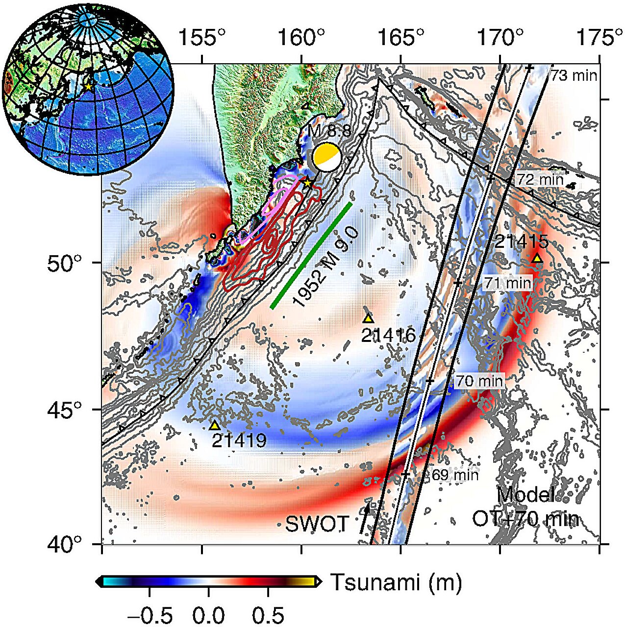
In late July, an earthquake off the Kamchatka Peninsula, a region located in the far reaches of Russia, set the ocean into motion, sparking a Pacific-wide tsunami. It was a massive earthquake—magnitude 8.8—striking the Kuril-Kamchatka subduction zone. While the earthquake was massive, the tsunami it triggered was even more remarkable for another reason: it was the first time scientists had captured a high-resolution, spaceborne track of a subduction zone tsunami. The credit for this unprecedented achievement goes to the Surface Water Ocean Topography (SWOT) satellite, a relatively new addition to the growing field of ocean observation satellites.
In a study recently published in The Seismic Record, Angel Ruiz-Angulo, a researcher at the University of Iceland, and his colleagues revealed how SWOT’s data unveiled a complex and unexpected pattern of waves dispersing and scattering across the ocean basin. The scientists realized that this new data could be instrumental in helping them understand how these waves propagate and, most importantly, how they might pose a threat to coastal communities around the Pacific.
The Evolution of Tsunami Tracking
For years, tsunami detection relied on instruments scattered across the ocean, such as the DART (Deep-ocean Assessment and Reporting of Tsunamis) buoys, which measure the height of the ocean surface at specific points. While these instruments provided valuable information, they had limitations. “Before, with DARTs, we could only see the tsunami at specific points in the vastness of the ocean,” Ruiz-Angulo explained. “Now, with SWOT, we can capture a swath up to about 120 kilometers wide, with unprecedented high-resolution data of the sea surface.”
SWOT, which was launched in December 2022 as a collaboration between NASA and the French space agency Centre National d’Etudes Spatiales, was designed to provide the first-ever global survey of Earth’s surface water. The satellite was originally intended to improve our understanding of ocean dynamics, such as small ocean eddies, and monitor sea levels across the planet. What Ruiz-Angulo and his team hadn’t expected, however, was that it would be fortunate enough to capture a tsunami in action.
This breakthrough came as a surprise to the researchers, especially considering how the satellite’s original mission was not specifically focused on tracking tsunamis. “We had been analyzing SWOT data for over two years, understanding different processes in the ocean, like small eddies, never imagining that we would be fortunate enough to capture a tsunami,” said Ruiz-Angulo. Yet, the data provided by SWOT opened a new door for tsunami research.
Dispelling Old Assumptions
The most striking revelation from the SWOT satellite’s observations was how it challenged long-standing assumptions about tsunami behavior. Traditionally, researchers have considered large tsunamis to be “non-dispersive.” This means that, since the wavelength of a major tsunami is much longer than the depth of the ocean, it is typically thought to maintain its shape as it travels, without breaking up into a series of waves.
But the data from SWOT revealed something different. “The SWOT data for this event has challenged the idea of big tsunamis being non-dispersive,” Ruiz-Angulo said. Instead of observing a single, coherent wave traveling across the Pacific, SWOT showed that the tsunami was dispersing, with waves scattering in various directions, creating a complex pattern across the ocean. This discovery prompted the researchers to reconsider tsunami models that had relied on the assumption of non-dispersive waves.
By incorporating numerical models that accounted for dispersion—the breaking up of a wave into multiple smaller waves—the team found that these models better matched the satellite observations of the Kamchatka tsunami. This was a pivotal moment for tsunami scientists, who realized that the current models might be missing something crucial. “This ‘extra’ variability could represent that the main wave could be modulated by the trailing waves as it approaches some coast,” Ruiz-Angulo explained. “We would need to quantify this excess of dispersive energy and evaluate if it has an impact that was not considered before.”
The Importance of Accurate Tsunami Models
In their quest to better understand the tsunami, the researchers also compared the data captured by SWOT with observations collected by two DART tide gauges. The models predicting the tsunami’s arrival had not perfectly aligned with these real-world measurements. The earlier model had predicted that the tsunami would hit one gauge earlier and another gauge later than what was observed. This discrepancy prompted the team to take a closer look at the earthquake’s source, reanalyzing the data with a technique called inversion, which uses observations from various sources to refine the understanding of the event.
What they found was significant: the source of the Kamchatka earthquake extended farther to the south than originally predicted, and the rupture length was longer—400 kilometers—compared to the 300 kilometers forecasted by earlier models. This new information helps refine tsunami prediction models and could improve future early-warning systems for coastal communities.
“As we know from the 2011 Tohoku-oki earthquake in Japan, tsunami data is incredibly valuable for constraining our understanding of seismic events,” said Diego Melgar, a co-author of the study. “Since then, there has been a push to incorporate DART data into these analyses to get a more complete picture, but it’s not always easy to combine the hydrodynamic models needed for DART with the seismic models used to understand land movements.”
The research highlights the importance of integrating various types of data. By merging the satellite data with buoy measurements and seismic data, the team was able to provide a more accurate picture of the tsunami’s behavior and improve future modeling efforts.
The Future of Tsunami Forecasting
The potential impact of this research on tsunami forecasting cannot be overstated. Tsunamis are fast-moving and destructive, often giving coastal communities very little time to prepare. Early-warning systems, like the one developed after the 1952 Kuril-Kamchatka earthquake, are critical in saving lives. Yet, the technology available at the time of the 2025 tsunami was not perfect. The integration of SWOT satellite data into real-time tsunami forecasting could provide a much more accurate and timely prediction, allowing authorities to issue more reliable warnings.
“With some luck, maybe one day results like ours can be used to justify why these satellite observations are needed for real or near-real-time forecasting,” said Ruiz-Angulo. This could be a game-changer for coastal regions that are at high risk for tsunamis, especially as climate change continues to alter global ocean patterns and increase the frequency of natural disasters.
Why This Research Matters
The study of tsunamis has always been a challenge. These devastating events are notoriously difficult to predict, and while advances in early-warning systems have made a significant difference, there is still much to learn. By providing a global, high-resolution view of the ocean surface, SWOT has given researchers a new tool to explore how tsunamis behave in real time, with a level of detail never before possible.
The research shows us that our understanding of tsunami propagation is still evolving, and new technologies like SWOT are key to advancing this field. By combining spaceborne satellite data with traditional tsunami detection methods, scientists can now track waves in real time, improve models, and offer more accurate predictions. The implications for disaster preparedness and risk reduction are profound, offering hope that one day, we may be able to give coastal communities the warning they need to protect themselves from these deadly natural events.
More information: Angel Ruiz-Angulo et al, SWOT Satellite Altimetry Observations and Source Model for the Tsunami from the 2025M 8.8 Kamchatka Earthquake, The Seismic Record (2025). DOI: 10.1785/0320250037