For decades, scientists and policymakers have relied on a deceptively simple calculation to gauge how wet or dry a place is: the aridity index. It’s a ratio of precipitation — the rain and snow a location receives — to potential evapotranspiration, the amount of water that could be lost through evaporation and plant transpiration. A value below 1 usually means a location is arid; a value above 1 means it’s more humid.
The concept has been useful for everything from planning irrigation systems to anticipating droughts and modeling climate change impacts. But there’s been a persistent puzzle. Some lowland regions, such as the Okavango Delta in Botswana, seem far too lush compared to their measured rainfall. According to the standard aridity index, they should be much drier than they are. So where is the extra water coming from?
The Hidden Pathways of Water
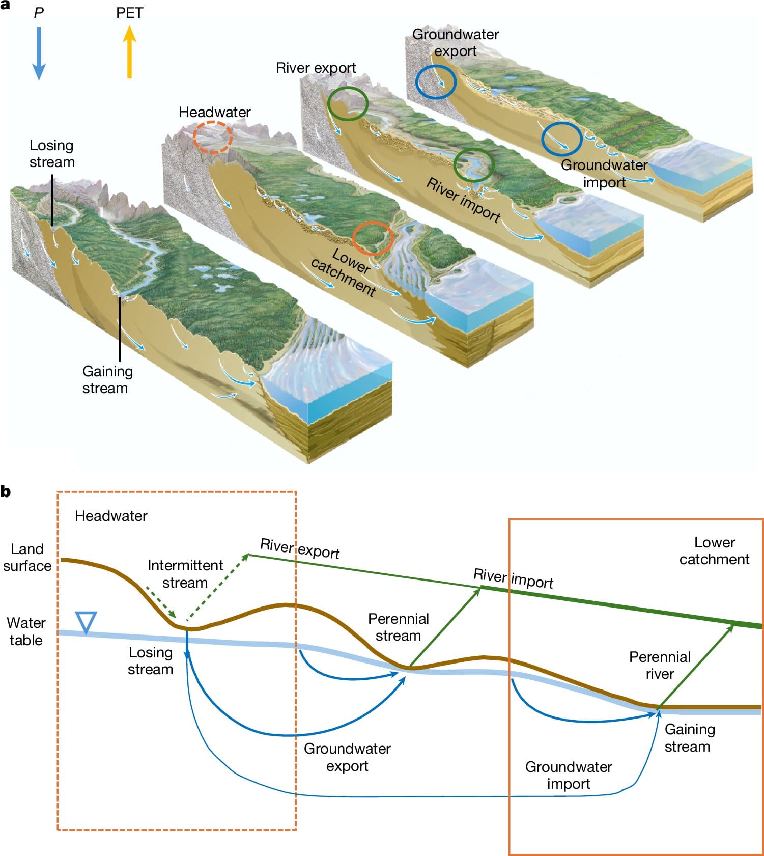
Hydrologists Gonzolo Miguez-Macho and Ying Fan believe they’ve found the missing piece: water doesn’t just fall from the sky — it flows across the land. Rivers, streams, and underground aquifers move water laterally, transporting it from wetter highlands to drier lowlands.
“As water also flows laterally across the land, from hills to valleys and from mountains to plains, through the river network above ground and the groundwater system below ground, a climate-only water balance does not fully reflect the water availability in the receiving lowlands,” the researchers write in their recent Nature study.
This means that certain regions receive a hydrologic subsidy — an influx of water from elsewhere — that can be large enough to rival or even exceed the rainfall they get locally. This is how great civilizations have historically flourished along arid river plains, why oases can exist in the heart of deserts, and why lush forests can thrive in places that, by climate metrics alone, should be much drier.
From Aridity to a New Kind of Humidity
To capture this hidden dimension, Miguez-Macho and Fan propose a new metric, which they call the Global Humidity Index — or GHI_topo. This updated calculation doesn’t just include precipitation (P) but also Q_lat, the lateral water flow from rivers and groundwater.
In mathematical form, the formula is:
GHI_topo = (P + Q_lat) / PET
If there’s no lateral water movement, Q_lat is zero, and the GHI_topo is identical to the traditional aridity index. But in lowlands connected to water-rich highlands, Q_lat can be substantial, boosting the humidity index well above what precipitation alone would suggest.
Testing the New Model
The researchers put their new definition to the test with global simulations covering 15 years (2003–2018). They combined climate reanalysis data with satellite vegetation observations — not just annual averages, but hourly data, to see how closely the indices matched reality.
The results were striking. In upland areas, the GHI_topo matched the traditional aridity index closely, because these regions depend almost entirely on local precipitation. But in lowlands, the story was different. Lateral water flows pushed GHI_topo values far higher, aligning much more closely with observed vegetation patterns.
Globally, they found that the area where water supply meets or exceeds demand (GHI_topo ≥ 1) was 33% greater using the new index than with the old one. In the dry, summer Mediterranean climate, the increase was even more dramatic: 205% greater.
In some cases, the contribution from lateral flows was astonishing. About 16% of land areas received more than 250 millimeters of water annually from lateral sources, and 11% received over 500 millimeters — enough to shift an entire ecosystem classification.
Why This Matters
This isn’t just an academic update to a climate formula. The new approach could transform how we understand — and manage — water in a warming world. In regions where rivers or underground aquifers supply critical water to downstream ecosystems and farms, climate change, dam construction, or groundwater depletion could have cascading impacts far beyond what traditional models predict.
It could also help explain why certain vegetation types thrive where they do, and how they might respond to future environmental change. As the researchers note, the hydrologic subsidy “explains why savannahs and forests can coexist under the same climate but occupying different hydrologic positions.”
Looking Ahead
The GHI_topo is not perfect. It doesn’t yet factor in human water use — such as irrigation, damming, or diversions — and its accuracy is limited by the resolution of the land data. But it’s a leap forward in painting a truer picture of water availability across the globe.
Miguez-Macho and Fan are already thinking about the next step: “Next, we plan to explore the utility of GHI_topo in explaining global vegetation dynamics and how hydrologic subsidies might shape ecosystem responses to future global environmental change.”
In other words, this is just the beginning of a much deeper look into Earth’s water network — one that could help safeguard not only our ecosystems but the societies that depend on them.
More information: Gonzalo Miguez-Macho et al, A global humidity index with lateral hydrologic flows, Nature (2025). DOI: 10.1038/s41586-025-09359-3