On the morning of September 28, 2022, the people of Southwest Florida awoke to a horizon blurred by the fury of nature. Hurricane Ian, which just a day before had been categorized as a strong but manageable Category 3 storm, had transformed overnight into a monster. By the time it roared ashore, it had reached Category 5 intensity—one of the most powerful storms ever to strike the state.
The devastation was immediate and merciless. Buildings crumbled. Roads vanished beneath walls of water. Families were torn from their homes. What had been expected to be destructive became catastrophic. In its aftermath, Hurricane Ian became the costliest hurricane in Florida’s history—an event carved not only into maps and data, but into memory and grief.
What puzzled scientists most, however, was not just the scale of the destruction—it was the speed of the storm’s intensification. How could a hurricane, already formidable, strengthen so rapidly right before making landfall in relatively shallow coastal waters? The answers, it turns out, were hiding beneath the surface of the sea.
Unseen Heat: The Silent Fuel of a Storm
Hurricanes feed on heat. The warmer the ocean, the more energy a storm can draw into its system. This is why scientists obsessively monitor sea surface temperatures, especially in the tropics. But in Ian’s case, the warmth on the surface told only part of the story.
Beneath the calm appearance of the Gulf of Mexico, something strange was happening. Along the West Florida Shelf—a wide stretch of shallow seabed running along the coast—the waters weren’t just warm on top. They were warm all the way down. And that warmth turned the sea into a bomb waiting to go off.
Ordinarily, shallow waters are less capable of supporting rapid hurricane intensification. After all, they mix more easily, meaning storms quickly churn up cooler waters from below, which help reduce intensity. But in the summer of 2022, that natural defense failed. Something had allowed the subsurface waters to remain unusually hot—2 to 3°C warmer than usual in some areas. And when Hurricane Ian passed over, it found more than enough fuel to explode into a beast.
A Missing Current and a Silent Warning
The key to this climatic anomaly, as researchers at the University of South Florida would later discover, lay in a powerful underwater force: the Loop Current.
The Loop Current is one of the major engines of ocean circulation in the Gulf of Mexico. Flowing north from the Caribbean, it loops through the Gulf before exiting through the Florida Straits. Its flow pattern varies seasonally and annually, and its strength and reach have major implications for the entire Gulf region.
When it functions normally, the Loop Current often stretches far enough north to hit a region near the Dry Tortugas, a coral island chain off the tip of Florida. There, it reaches what scientists call a “pressure point,” a critical zone where the shallow seafloor contours converge and force cooler, deeper waters upward—a process called upwelling.
This upwelling acts like nature’s own air conditioner, flushing out warm water from the shallow West Florida Shelf and replacing it with cooler water from the depths. But in 2022, that didn’t happen. The Loop Current failed to reach the pressure point. The upwelling never occurred. And so, the heat built up, unrelieved and unchecked, for months.
Years of Data, One Alarming Pattern
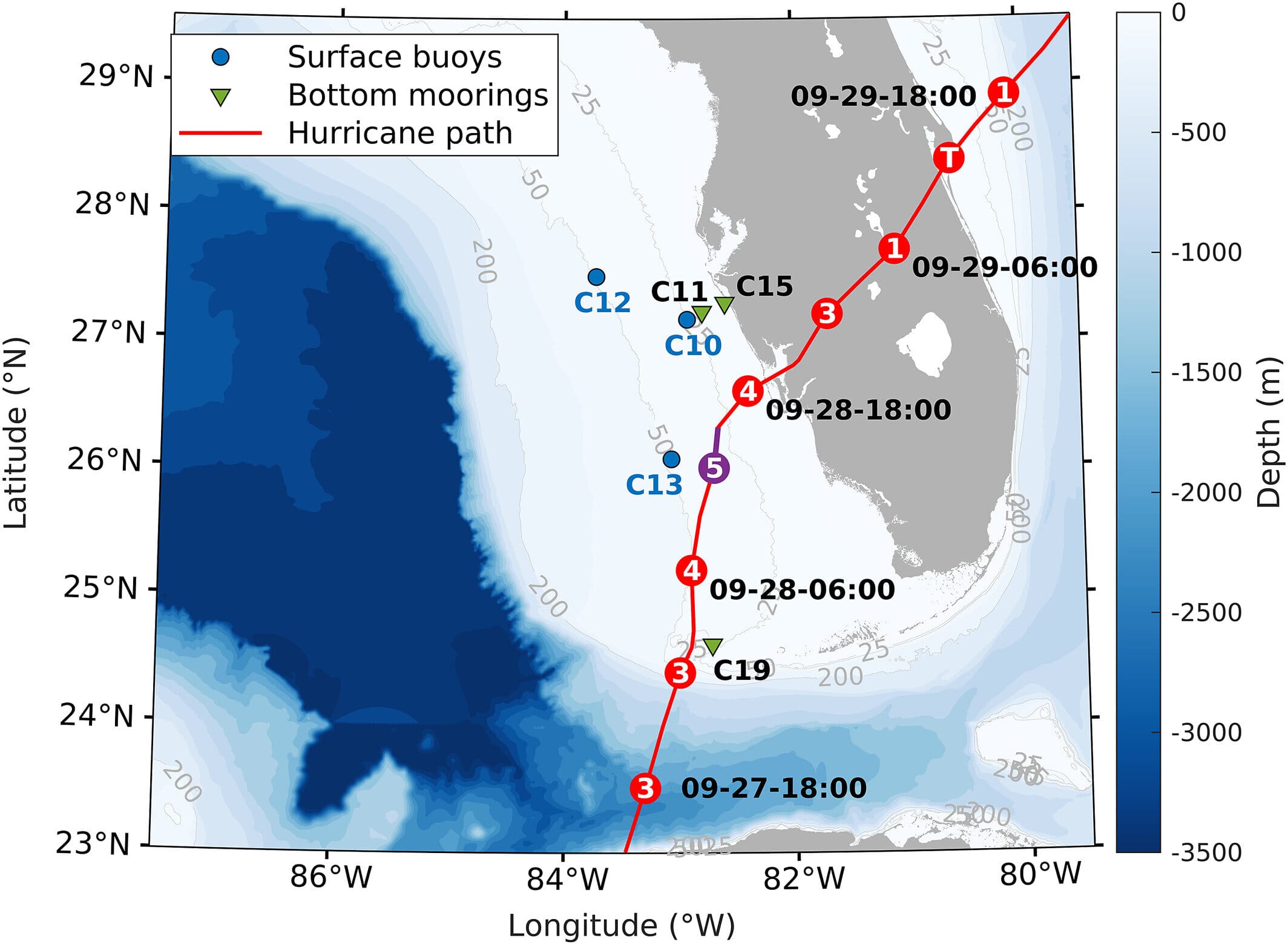
Dr. Yonggang Liu, associate professor at USF’s College of Marine Science and lead author of the study published in Geophysical Research Letters, had been monitoring the Gulf for years. Together with his team at the Ocean Circulation Lab, they maintained an intricate web of data collection called the Coastal Ocean Monitoring and Prediction System (COMPS)—a combination of surface buoys and bottom-mounted sensors measuring everything from water temperature and salinity to current velocity.
When Hurricane Ian struck, Liu knew something was wrong—something deeper. He and his colleagues dug into the decades of data collected by COMPS and found the evidence: in the months leading up to Ian, the Loop Current had consistently fallen short of the pressure point. Without it, the mixing of the water column never took place. The West Florida Shelf remained thermally stratified—layered and hot from top to bottom.
What made this even more concerning was how easy it would have been to overlook. On the surface, sea temperatures were only marginally above normal—1 to 2°C warmer than the average. But below the surface, hidden from satellite eyes, temperatures were dramatically higher. This hidden heat created a deep reservoir of energy, which Ian was able to tap into with deadly effect.
The Depth of the Problem
Forecasters traditionally rely heavily on sea surface temperatures when making hurricane predictions. It’s the most accessible data and provides a snapshot of potential storm fuel. But Liu’s research makes it clear: surface temperatures aren’t enough.
“We’re only getting part of the story,” Liu explained. “If we’re not looking at the full water column—especially in areas like the West Florida Shelf—we’re underestimating how much energy a storm might find.”
This insight is both troubling and transformative. It suggests that under certain conditions, shallow waters—long thought to be less of a risk for extreme hurricane intensification—can store massive amounts of heat energy, invisible to most forecasting models.
Liu’s findings also underscore the importance of real-time, high-resolution ocean observations. While satellite data is invaluable, it lacks the precision and depth necessary to detect subtle, but critical, shifts in subsurface temperatures. Instruments like those in the COMPS network offer a far more complete picture of what’s happening below the waves.
Forecasting the Future with Eyes Below
As climate change accelerates, the oceans are absorbing more and more heat—over 90% of the excess energy from global warming ends up in the sea. This means the likelihood of “hidden heat” events like the one that fueled Ian will only increase. And if hurricane models don’t adapt, communities will continue to be caught off guard.
COMPS and similar systems are now being seen not just as scientific tools, but as vital infrastructure. Partnered with NOAA’s Integrated Ocean Observing System (IOOS) and the Southeast Coastal Ocean Observing Regional Association (SECOORA), USF’s monitoring efforts are helping build a network of oceanic eyes and ears along the U.S. coastline.
These systems can now feed their data into predictive models in near real time, offering meteorologists a much more complete understanding of the conditions that shape storm behavior. It’s not just about knowing where a hurricane might go—it’s about understanding how strong it might become and how quickly.
In the case of Hurricane Ian, that kind of foresight might have made all the difference.
A Storm’s Lesson—and a Wake-Up Call
Hurricane Ian was a tragedy. But it was also a warning.
As the climate warms and ocean dynamics shift, the traditional assumptions we’ve made about hurricane development may no longer apply. Shallow waters, once believed to offer a kind of natural buffer, can become incubators of destruction under the right conditions. And unless we commit to observing not just the surface of our oceans but their very depths, we risk being blindsided again.
For scientists like Liu and his team, the work is personal. “We do this to protect people,” he says. “Every data point, every observation—it’s not just science. It’s safety. It’s lives.”
In the years to come, it may not be the storm you can see that poses the greatest danger. It may be the heat hidden beneath, waiting, silent and invisible, for the next tempest to stir it to life.
Reference: Yonggang Liu et al, Rapid Intensification of Hurricane Ian in Relation to Anomalously Warm Subsurface Water on the Wide Continental Shelf, Geophysical Research Letters (2024). DOI: 10.1029/2024GL113192