The Earth is a living, breathing sphere of restless air and water. Its atmosphere is in constant motion, a vast, invisible ocean of gases shifting under the influence of the Sun’s heat, the planet’s rotation, and the ceaseless interplay between land and sea. Within this ever-changing system, there are moments when the forces of nature align in a way that is both beautiful and terrifying. From these alignments, immense spiraling storms are born — storms we call cyclones.
The word itself carries power. It comes from the Greek kyklon, meaning “moving in a circle” or “whirling around.” A cyclone is not just a storm; it is an atmospheric engine of breathtaking scale, a rotating system of winds driven by the contrast of heat and pressure. Depending on where they occur in the world, they take on different names — hurricanes in the Atlantic and Northeast Pacific, typhoons in the Northwest Pacific, cyclones in the South Pacific and Indian Ocean — but at their heart, they are the same phenomenon: the Earth’s most intense expression of weather.
A Child of Heat and Water
A cyclone’s life begins quietly, far from the drama it will one day unleash. It starts with heat — the Sun’s relentless energy pouring onto the ocean’s surface, warming the top layer of water. In tropical regions, where the Sun’s rays strike most directly, the surface temperature can climb above 26.5°C (about 80°F), the threshold for cyclone formation. Warm water is the key ingredient, for it fuels the storm’s growth through evaporation.
As seawater warms, it releases moisture into the air above it, creating a blanket of humid, unstable atmosphere. Warm, moist air is lighter than cool air, so it begins to rise. As it does, the water vapor it carries starts to condense into tiny droplets, forming clouds. This condensation releases latent heat — an invisible but potent source of energy that further warms the rising air, causing it to rise faster still. This positive feedback is the heartbeat of a cyclone.
But warm water and moist air alone are not enough. The Earth’s rotation, through a force known as the Coriolis effect, is what gives the storm its spin. In the Northern Hemisphere, the rotation deflects moving air to the right, causing cyclones to spin counterclockwise; in the Southern Hemisphere, the deflection is to the left, and cyclones spin clockwise. Without this rotation, the towering columns of clouds would simply collapse into disorganized storms.
The Birth of the Spiral
In the earliest stage, a cyclone may be nothing more than a cluster of thunderstorms drifting over the ocean. Meteorologists call these “tropical disturbances.” If the conditions are favorable — low wind shear, warm seas, high humidity — the disturbance may begin to organize. Air rushes toward the low-pressure center, spiraling due to the Coriolis effect. The rising air in the center creates a vacuum that draws in more air from the surroundings, intensifying the rotation.
As the system strengthens, it becomes a tropical depression, marked by sustained wind speeds up to 38 mph (62 km/h). The spiral is visible from above, but it is still loose and ragged. Yet within its clouds, the engine is building. The heat released from condensation is now driving a vertical circulation — air rises near the center, spreads outward at the top, cools, and sinks at the edges. This circulation keeps feeding the storm, drawing in more moisture from the sea.
When sustained winds exceed 39 mph (63 km/h), the depression graduates to a tropical storm and earns a name. The spiral becomes tighter, the clouds taller and more organized. The storm is no longer a scattered cluster but a unified, rotating system. If the ocean continues to feed it, if the air above remains moist, if wind shear remains low, the storm can intensify into a full-fledged tropical cyclone.
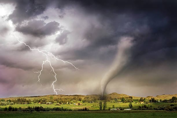
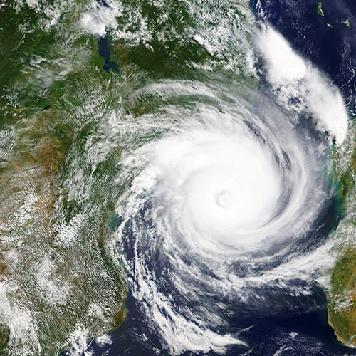
The Eye of the Storm
The most striking feature of a mature cyclone is its eye — a nearly circular region at the center where skies can clear, winds drop, and a surreal calm takes hold. The eye forms when the rising air in the storm’s core becomes so intense that it creates a zone of descending air at the very center. As air sinks, it warms and dries, creating the eerie stillness of the eye.
Surrounding the eye is the eyewall, a ring of towering thunderstorms where the storm’s most violent winds and heaviest rains are found. Here, air is rising at tremendous speeds, fueled by the maximum release of latent heat. This is the most dangerous part of a cyclone, the place where nature’s energy is most fiercely concentrated.
Beyond the eyewall, the storm’s spiral rainbands extend for hundreds of kilometers, sweeping over vast stretches of ocean and land. These bands carry squalls of rain and gusts of wind, separated by lulls. To those caught within them, the approach of a cyclone is a series of surges and silences, each one hinting at the greater fury to come.
The Science of Intensification
Cyclones are ranked by their wind speeds, and their intensification is a delicate dance between environmental conditions. The warmer the ocean surface, the more energy is available to the storm. But equally important is the structure of the atmosphere above. If strong winds at high altitudes blow across the storm — a phenomenon known as wind shear — they can disrupt the storm’s vertical structure, tilting and tearing it apart. Low wind shear allows the storm’s core to remain upright, letting its heat engine operate at maximum efficiency.
Moisture in the mid-troposphere, roughly five kilometers above the surface, is also crucial. Dry air can choke the storm’s convection, weakening it. Conversely, a moist environment allows for deep, uninterrupted thunderstorm development.
Under ideal conditions, a cyclone can undergo rapid intensification, with wind speeds increasing by more than 35 mph (56 km/h) in just 24 hours. Such explosive growth can turn a manageable tropical storm into a catastrophic major cyclone in a single day — a nightmare scenario for forecasters and coastal communities.
The Landfall Drama
For all their grandeur at sea, cyclones pose their greatest danger when they make landfall. Over the ocean, they are fueled by warm water; once they cross onto land, their energy supply is cut off, and they begin to weaken. But before they fade, they unleash devastating winds, torrential rains, and a deadly storm surge — a dome of seawater pushed ashore by the cyclone’s winds.
The storm surge is often the deadliest aspect of a cyclone. When a powerful storm coincides with high tide, walls of water can engulf coastal towns, sweeping away buildings, roads, and lives in minutes. Combined with waves riding atop the surge, the destruction can extend far inland.
Inland, the cyclone’s rains can cause catastrophic flooding, especially when mountains wring out additional moisture from the storm’s air. Rivers swell, landslides occur, and communities far from the coast can find themselves under siege by water.
The Global Face of Cyclones
Though the mechanics are the same, cyclones take on different characters depending on where they form. In the Atlantic and Eastern Pacific, they are called hurricanes, with a naming system maintained by the World Meteorological Organization. In the Western Pacific, they are typhoons, and in the Indian Ocean and South Pacific, they are simply cyclones.
Each basin has its own season, shaped by regional ocean temperatures and wind patterns. The Atlantic season runs from June to November, peaking in September. The Western Pacific is active almost year-round. The Bay of Bengal and Arabian Sea see their most intense storms in the pre- and post-monsoon months.
Some regions are particularly vulnerable. The Bay of Bengal, with its funnel-shaped coastline and dense population, has seen some of the deadliest cyclones in history. Bangladesh, India, and Myanmar have endured tragedies where hundreds of thousands have perished in a single storm.
The Human Story
Behind every cyclone’s meteorological data lies a human story — of preparation, endurance, loss, and resilience. For coastal communities, the approach of a cyclone is a test of readiness. Modern forecasting can track a storm days in advance, but the uncertainty of its path often leaves entire regions bracing for impact. Evacuations are ordered, shelters opened, boats secured, windows boarded. Families gather essentials, children sense the tension in the air, and the wind begins to moan as the outer bands arrive.
The hours during landfall are among the most harrowing in nature. The roar of the wind drowns out voices, rain lashes sideways, debris flies through the air. Structures shudder under the force, and the ocean invades the land. For those who endure the eyewall, there may come the strange calm of the eye — a deceptive lull before the winds return from the opposite direction, often stronger than before.
After the storm passes, the landscape is transformed. Trees lie broken, power lines dangle, homes are unroofed, and streets are rivers of mud. The air smells of salt, mud, and splintered wood. In the days and weeks that follow, survivors face the challenge of rebuilding — restoring power, clearing debris, finding clean water. Aid arrives, sometimes slowly, and the memory of the storm becomes part of the community’s identity.
Cyclones in a Changing Climate
In the modern era, a new dimension has been added to the story of cyclones: climate change. The warming of the planet, driven by human activity, is altering the conditions that give birth to these storms. While the total number of cyclones globally may not increase dramatically, the proportion of the most intense storms is rising. Warmer oceans provide more fuel, and higher sea levels make storm surges more destructive.
There is also evidence that cyclones are lingering longer and moving more slowly, dumping greater amounts of rain over affected areas. This trend, combined with rising coastal populations, increases the risk of catastrophic flooding.
Scientists use computer models to study these changes, but the complexity of the atmosphere makes precise predictions challenging. What is clear is that the cost — both human and economic — of cyclone disasters is growing, and adaptation will be essential.
Lessons from the Spiral
Cyclones are a reminder of the planet’s immense power, but also of its intricate balance. They are born from the same processes that drive our weather and sustain life: the Sun’s heat, the water cycle, the rotation of the Earth. In their violence, they also play a role in transporting heat from the tropics toward the poles, helping to regulate the global climate.
For humans, the challenge is to live with these storms, to respect their power, and to reduce our vulnerability. Early warning systems, resilient infrastructure, and international cooperation can save lives. At the same time, reducing greenhouse gas emissions is a long-term strategy to prevent the most dangerous changes in cyclone behavior.
The Poetry of the Storm
There is a strange poetry in cyclones. From space, they are breathtaking — vast spirals of white cloud, perfectly symmetrical, the eye a jewel at the center. On the ground, they are terrifying, chaotic, and raw. They remind us of our smallness in the face of natural forces, but also of our resilience. Communities shattered by cyclones have rebuilt again and again, carrying the scars and the stories forward.
In the end, a cyclone is more than a meteorological event. It is a meeting point between the physics of the atmosphere and the human will to endure. It is the ocean breathing into the sky, the Earth’s rotation sculpting wind into a spiral, the Sun’s heat transformed into motion and rain. It is a force as old as the planet itself, yet as urgent and immediate as the next storm warning.
And as long as the seas are warm and the air is moist, the spirals will keep forming, tracing their paths across the globe — a reminder that the atmosphere is alive, and that we are but one species among many who must learn to live beneath its restless skies.