At first glance, the hills around Petra look quiet, almost empty, as if centuries of wind and sun have erased the city’s pulse. But beneath the sandstone, water once moved with purpose. Channels cut into rock, pipes hidden under dust, basins waiting patiently for rain. In a recent study led by Niklas Jungmann of Humboldt-Universität zu Berlin, one small stretch of this forgotten network has begun to speak again, and what it revealed surprised even those who know Petra well.
The focus was the ‘Ain Braq aqueduct, a water system long assumed to be simple and well understood. Instead, careful investigation showed it was more complex, more ambitious, and more revealing of Nabataean engineering choices than previously believed. Published in the journal Levant, the research doesn’t just revise a technical detail. It reshapes how we imagine water, power, and intention flowing through an ancient city built in stone.
A City That Lived on Water
Petra, now carved into popular imagination as a rose-red ruin, was once a living capital. In the 1st century BC, it flourished as the heart of the Nabataean Empire, thriving in what seems like an unlikely landscape. Gardens bloomed, baths steamed, sanctuaries shimmered with water, and a vast garden and pool complex reflected the sky. None of this could exist without a steady, carefully managed supply of water.
The city’s prosperity depended on mastering its environment, especially rainfall and springs scattered across the surrounding hills. Over time, scholars have studied Petra’s water systems from a broad, sweeping perspective, reconstructing canals and reservoirs across the landscape. But these large-scale approaches often painted an overly optimistic picture, relying on assumptions rather than close, ground-level evidence. Details about chronology, construction techniques, and even the number of conduits sometimes remained vague.
Jungmann set out to change that by looking closely, very closely, at one specific place.
Looking Closely Where Others Looked Broadly
Instead of surveying the entire city at once, Jungmann adopted a micro-approach, focusing on a compact 2,500 m² area of the Jabal al-Madhbah massif. This rocky zone contains sections of the ‘Ain Braq aqueduct and offered a chance to document every visible trace of water infrastructure with precision.
During the first season of the Urban Development of Ancient Petra Project (UrDAP) in September 2023, the landscape began to give up its secrets. What emerged was not a single conduit, as previously believed, but a far richer and more layered system. Jungmann documented nine conduits, including a previously undiscovered one made of lead, along with a large reservoir sealed toward the city by a high dam, two cisterns, and seven basins of different sizes and purposes.
This was not just a water channel. It was an engineered landscape.
The Dam That Refused to Fit the Pattern
Among the most striking discoveries was a retention dam unlike others known from Petra. It had an irregular shape, no visible pressure outlet, and a tiered appearance that immediately raised questions. Most dams around Petra were carefully integrated into the natural sandstone, plastered with a brown-reddish coating to blend seamlessly into the rock. This one seemed different, almost awkward at first glance.
Jungmann suggests the dam’s shape likely reflects the challenge its builders faced. They were trying to close a gap in the sandstone massif, adapting their design to the terrain rather than forcing the terrain to obey them. Over centuries of exposure and neglect, weathering may have stripped away its original surface, leaving behind the rough form seen today.
But the tiers themselves hint at something more intentional. With the dam’s substantial height and the volume of water it held, the pressure on the sandstone wall would have been immense. Building the structure with a thick base that narrowed upward, shaped into steps or recesses, may have been a way to relieve that pressure while conserving materials.
There is even a more poetic possibility. Petra is known for its artificial waterfalls, where water was guided not just for use, but for beauty. The tiered dam may once have sent water cascading downward into a basin below during winter rains, turning engineering into spectacle.
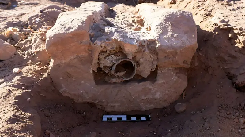
The Pipe That Changed the Story
If the dam raised eyebrows, the pipe rewrote expectations entirely. Running alongside the familiar terracotta conduit was a 116-meter-long lead pipeline, smooth, welded, and designed to withstand high pressure. This was unexpected. The Nabataeans typically used terracotta pipes, ideal for gravity-fed flow and well suited to local materials and skills.
Lead pipes, by contrast, are rare in this region. They require significant resources, specialized knowledge, and confidence in precise engineering. They can also function as inverted siphons, carrying water uphill before letting it flow down again, a demanding task even by Roman standards.
Jungmann notes that only a few such pipelines are known outside building complexes in the Eastern Mediterranean and the Levant. Their presence here suggests something extraordinary. Whoever commissioned this pipeline was wealthy, ambitious, and determined to move water exactly where it was needed, regardless of cost.
Water, Power, and Royal Ambition
Why invest so heavily in a lead pipeline in Petra? Jungmann’s current hypothesis ties the aqueduct directly to monumental construction during the reign of Nabataean King Aretas IV. He proposes that the ‘Ain Braq aqueduct, including the lead conduit, was planned and built alongside the Great Temple complex and the Garden and Pool Complex.
These structures demanded a constant and reliable water supply, not just for practical use but as symbols of power and prosperity. Bringing water up to az-Zantur hill and then distributing it to the city center required engineering solutions that went beyond tradition. In this context, the lead pipeline becomes more than a technical choice. It becomes a statement.
No expense or effort was spared because water itself was central to Petra’s identity.
An Expensive Choice, Quietly Abandoned
Yet the story doesn’t end with triumph. At some point, the lead pipeline was abandoned and sealed, replaced by a terracotta conduit. Jungmann suggests the reason was likely economic. Lead pipelines demand vast amounts of raw material, fuel, and specialized maintenance. Over time, the cost may simply have outweighed the benefits.
This shift hints at changing priorities or resources within the city. It reminds us that ancient infrastructure was not static. Systems were adapted, downgraded, or abandoned as circumstances evolved. Petra’s water network was alive, responding to pressures both environmental and economic.
Mapping a Lost Network Piece by Piece
Jungmann’s work is far from finished. His ongoing Ph.D. research aims to document not just this small area, but the entire extent of the ‘Ain Braq aqueduct. That includes water systems in key sites like Wadi Farasa East, regions north of it, and the complete southern half of Petra.
He is cataloging individual components, mapping them across the city and surrounding region, and assembling the most complete picture possible. Some parts have been lost to erosion or destruction. Others remain buried, inaccessible without major excavation. Even so, each surviving fragment adds clarity to the whole.
The ultimate goal reaches beyond archaeology.
Why This Ancient Water Story Matters Now
By reconstructing how Petra managed water with such precision and creativity, Jungmann hopes to develop a model for using ancient water management systems for modern needs. This is not about nostalgia. It is about learning from systems designed to thrive in arid landscapes with limited resources.
The discovery of the dual conduits, especially the rare lead pipeline, reminds us that ancient engineers experimented, adapted, and sometimes took bold risks. They balanced beauty, function, and power in ways that still resonate today.
In the quiet sandstone hills near Petra, water once flowed through terracotta and lead, through dams shaped by necessity and perhaps by art. Thanks to careful, patient research, those flows are visible again, offering lessons not only about the past, but about how ingenuity can shape survival in challenging environments.
Study Details
Niklas Jungmann, Rediscovering the ‘Ain Braq aqueduct: new insights into Petra’s urban water management, Levant (2025). DOI: 10.1080/00758914.2025.2592501