Beneath the rolling waves and shimmering tides that fringe our continents lies a world long forgotten—a submerged memory of ancient humanity’s first footprints. For decades, archaeology has largely focused on the land we now walk, while ignoring the vast plains and coastlines our ancestors once called home, now hidden beneath the sea.
But one researcher believes these lost landscapes—what he calls aquaterra—hold the key to answering some of the deepest questions about where we came from and how we spread across the Earth.
Jerome Dobson, professor emeritus of geography at the University of Kansas, has spent years trying to reconstruct these ancient submerged corridors. His work suggests that under the waters of today lie stories of migration, survival, and innovation—chapters of human history that the ocean has hidden but not erased.
The World Beneath the Waves
In the millennia since Homo sapiens emerged in Africa, the planet has undergone seismic shifts—glaciers have melted, coastlines have retreated, and seas have surged to reclaim vast portions of once-habitable terrain. These were not subtle changes. At the Last Glacial Maximum, about 21,000 years ago, global sea levels were as much as 120 meters lower than they are today. Entire landscapes now buried beneath oceans were once open savannas, coastal plains, and river valleys—prime habitats for early humans.
Dobson coined the term aquaterra to describe these lands—now underwater but once teeming with life. He argues that these sunken regions are not just geological relics, but crucial archaeological zones that deserve urgent attention. “The exciting implication is that a lot of underwater landscapes have archaeological relevance,” Dobson explains. “And this mapping gives scientists a better shot at finding them.”
These forgotten territories, often stretching from continental coasts and scattered island chains, are time capsules. Within their hidden layers may lie evidence of early tools, settlements, and possibly even structures—hints of humanity’s formative steps out of Africa and into the wider world.
A New Lens on the Ancient World
To unlock this submerged past, Dobson and his collaborators—Giorgio Spada of the University of Bologna and Gaia Galassi of the University of Urbino—turned to a powerful scientific tool: glacial isostatic adjustment (GIA) modeling. Their improved GIA model allows researchers to reconstruct ancient coastlines and simulate how sea levels rose and fell over time—not in a general sense, but with a level of precision that aligns geophysical processes with actual archaeological evidence.
What makes GIA models so crucial is their ability to account for the way Earth’s crust deforms under the massive weight of ice sheets. When glaciers grow, they press down on the continents beneath them, causing the surrounding crust to rise. When the ice melts, the process reverses—but unevenly, and over millennia. This complex dance of land and sea creates shifting landscapes that old maps can’t capture.
“Simply subtracting sea-level height from topography isn’t enough,” Dobson explains. “Earth’s crust literally warps under the weight of ice sheets.” His team’s simulation, therefore, offers something previous studies could not: physically and geophysically accurate coastlines for the ancient world.
Paths Carved in Water and Stone
With this refined model, the researchers reexamined key migration corridors out of Africa, where humanity first evolved. Their findings were startling. Some routes, long thought to be improbable or only briefly exposed, were revealed to have been viable for much longer periods—potential superhighways for early humans seeking new lands.
Among these is the narrow Bab el-Mandeb strait, a watery gateway between the Horn of Africa and the Arabian Peninsula. While it’s long been favored as a southern exit route for early migrations, Dobson’s model paints a more complicated picture. Despite its narrow width, Bab el-Mandeb may have posed a formidable challenge depending on sea levels and the watercraft available at the time. If early humans lacked sufficient seafaring ability, this route may have been more barrier than bridge.
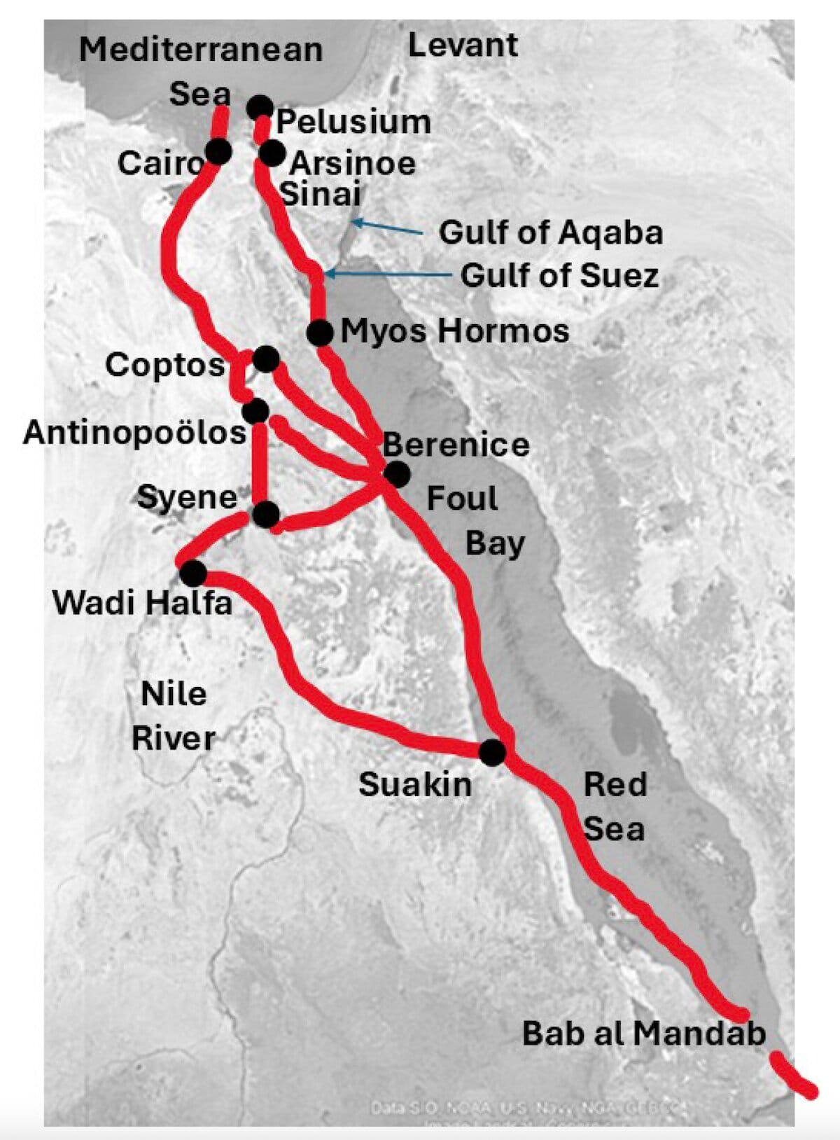
In contrast, the northern routes—particularly through the Sinai Peninsula—gain renewed prominence in this analysis. The Isthmus of Suez, while longer overland, could have offered a dry, passable corridor between Africa and the Levant during extended periods of low sea levels. These paths are more robustly supported by both archaeological and genetic evidence, Dobson notes, despite earlier theories emphasizing the southern sea crossings.
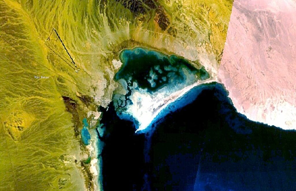
Another intriguing alternative involves the region around Foul Bay along the Red Sea coast of Egypt. This now-drowned area could have offered an inland shortcut to the Nile Valley—one of the most fertile and culturally rich regions in human prehistory. “The Isthmus of Suez is over 500 kilometers across,” Dobson said. “We expected people would prefer going up through Foul Bay to the First Cataract of the Nile, which would only be a 300-kilometer route.”
The researchers highlight the ancient port of Berenice as a potentially critical point of crossing or occupation. Coral reefs in the area, which require a solid foundation to grow, may even rest upon man-made structures—a tantalizing suggestion that demands further archaeological exploration.
Following the Bloodlines of the Ancients
To add another layer of evidence to their reconstructions, Dobson and his team turned to genetics. Specifically, they integrated ancient DNA datasets that trace the origins and movements of early human populations over the past two million years. This DNA trail converges on a singular ancestral center near modern-day northeast Sudan, close to the historical region of Meroë in ancient Kush.
This area, Dobson says, is not only consistent with the DNA evidence, but also geographically plausible when matched with the reconstructed coastlines and GIA-corrected landforms. “The early human haplotype center appears to be in northeast Sudan,” he explains. “That wasn’t a shock—it was somewhat expected by the DNA experts who discovered it.”
By aligning these genetic data points with accurate paleogeography, Dobson’s research creates a vivid picture of how humans moved—northward into the Levant, westward into the Nile Valley, and eastward into Arabia. It also raises critical questions about which routes were truly taken and why some paths became population arteries while others faded into myth.
Clues in Coral and Sand
What lies beneath the waters of Foul Bay or the submerged channels of the Bab el-Mandeb may be more than sediment and shell. Dobson believes there’s circumstantial evidence—especially from coral formations—that suggests ancient human constructions may lie hidden below the waves.
“Coral reefs, including patch coral reefs, are dependent on a solid base,” he notes. “Our circumstantial evidence is intriguing, but it demands confirmation through rigorous searches for evidence of human construction.” These reefs could be clinging to the remnants of ancient jetties, fish traps, or even coastal settlements that once fringed the Red Sea, now lost to rising tides.
If verified, such discoveries would revolutionize our understanding of early technological development, navigation, and human adaptability to changing climates.
An Open Window Into the Past
Perhaps most exciting is that Dobson’s work doesn’t end with this study. The team has made their GIA datasets open access, offering an invaluable resource to archaeologists, geographers, anthropologists, and climate scientists around the world. Researchers can now simulate their own regions of interest—searching for submerged valleys, plateaus, and crossings where early people may have once lived, fished, or wandered.
“This is a community resource,” Dobson said. “We wanted to put these reconstructions in investigators’ hands so they can explore their own regions of interest—where humans lived, what the land looked like, and how it changed.”
It’s a profound gesture—an invitation to re-map human history not as a dry sequence of names and dates, but as a living mosaic of terrain, climate, DNA, and culture. In this vision, the sea is not a barrier, but a palimpsest of civilization. And what it covers, it may one day reveal.
The Forgotten Continents of Memory
As sea levels continue to rise today—this time due to anthropogenic climate change—the urgency of this work becomes even greater. We are losing coastlines again. Islands are shrinking. Shores are vanishing. The difference is, now we understand what’s at stake. We know that the land disappearing today may be the archaeological frontier of tomorrow.
Dobson’s vision of aquaterra is not just about the past. It’s about the long arc of human resilience. It’s about seeing the Earth not as static, but alive—shaped by ice, tide, and time. And it’s a reminder that the answers to who we are may still lie just out of reach, buried beneath the surf.
Not all history is written on stone. Some of it sleeps beneath the waves.
Reference: Jerome Eric Dobson et al, Alternative crossings into and out of Africa since 30,000 BP, Comptes Rendus. Géoscience (2025). DOI: 10.5802/crgeos.273