Long before the modern Grand Canyon formed, a huge escarpment along the edge of the ancient Laurentian continent may have exposed and removed kilometers of rock from the region, helping explain the enormous gap in the canyon’s geological record known as the Great Unconformity. New landscape-evolution models indicate that this ancient escarpment could have produced more than 8 kilometers of erosion near its crest while areas farther away lost much less rock.
The Great Unconformity records a vast loss of rock
The Grand Canyon preserves nearly 2 billion years of Earth history, but a major part of that record is missing. At the Great Unconformity, rocks that formed more than a billion years apart meet across an erosional surface.
The gap spans about 1.2 billion years and represents the localized removal of roughly 10 kilometers of rock. Beneath the surface are much older Paleoproterozoic basement rocks and younger rocks of the Grand Canyon Supergroup. Above them are much younger Cambrian sedimentary rocks of the Tonto Group.
Scientists have proposed several explanations for this enormous erosion. Some interpretations treat the Great Unconformity as a composite surface produced by multiple tectonic and erosional events over hundreds of millions of years. Other work has emphasized erosion during Neoproterozoic global glaciation. Isostatic uplift associated with heating and removal of material from the deep lithosphere has also been proposed.
The new model focuses on another part of that history: the breakup of the supercontinent Rodinia and the formation of a continent-scale escarpment.
The Grand Canyon region once sat inland from a rifting continent
During the Cryogenian, the land that is now the Grand Canyon region was not immediately beside the ocean. A reconstruction using a published plate model places it about 400 to 600 kilometers inland from the western edge of Laurentia, with a mean distance of 502 kilometers.
After accounting for later extension in the Basin and Range Province, the estimated original distance was about 300 to 530 kilometers. Those distances are similar to the inland positions of major escarpments along the margins of continents that broke apart from Gondwana during the Mesozoic.
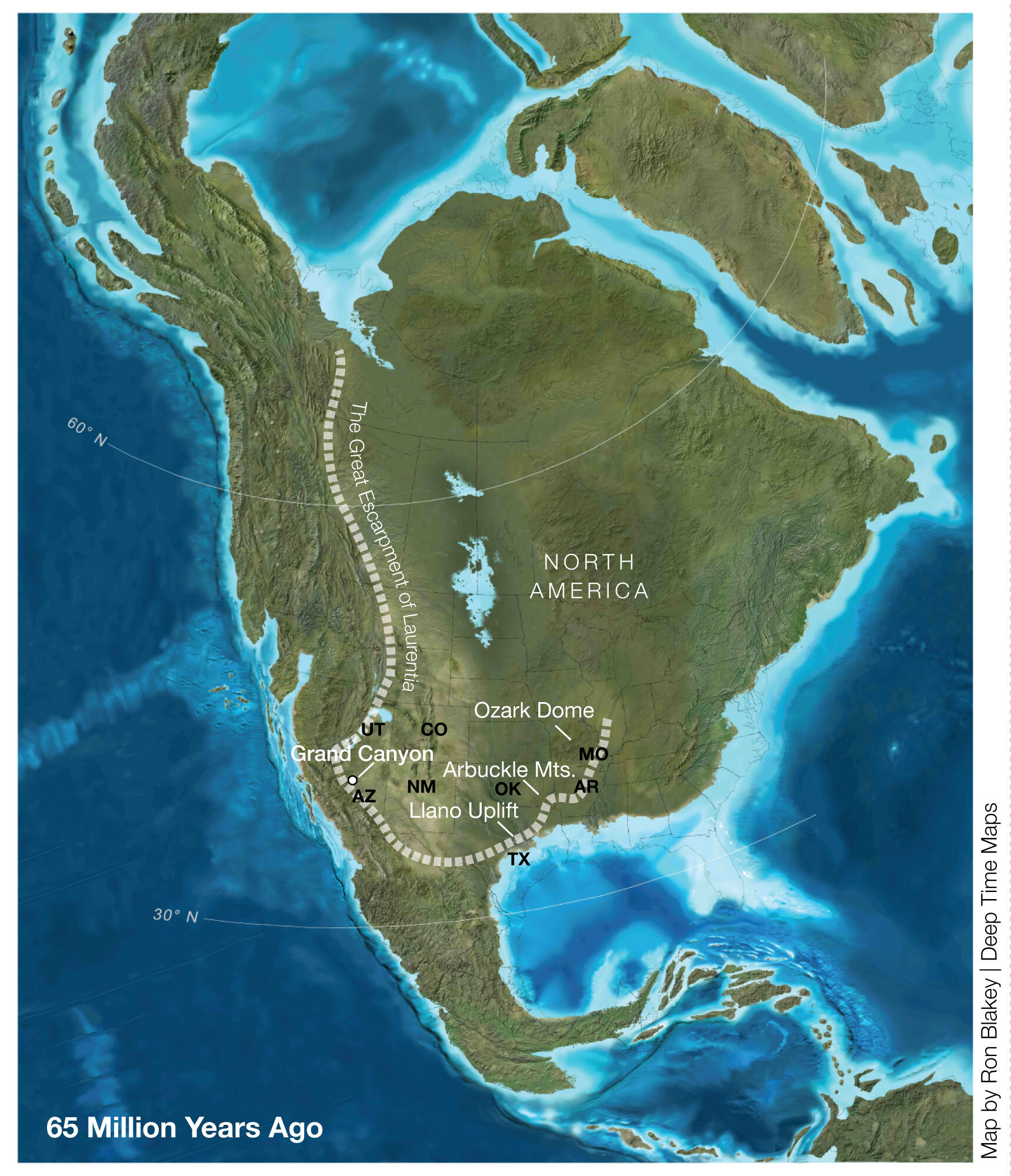
That comparison led the researchers to propose that the Grand Canyon region once occupied the slope of a much larger escarpment.
They call this proposed feature the Great Escarpment of Laurentia.
The escarpment would have developed as Rodinia began to break apart roughly 800 to 750 million years ago. The researchers argue that it could have resembled the large escarpments found along younger continental margins, where steep slopes separate elevated inland regions from lower areas near a rifted continental edge.
The models produce intense erosion near the escarpment
To test the idea, the researchers used landscape-evolution models based on the behavior of rivers, erosion and the flexural response of Earth’s crust.
The models began with topography produced by continental rifting. As the modeled landscape evolved, a steep escarpment developed beside an elevated plateau. The modeled escarpment extended about 300 to 700 kilometers inland from the continent-ocean boundary. That range includes the reconstructed position of the Grand Canyon region.
Over a 200-million-year model run, erosion became strongly concentrated near the escarpment.
In the best-estimate model, cumulative erosion reached about 5 kilometers. In the model’s end-member cases, erosion exceeded 8 kilometers at a position about 500 kilometers inland from the continent-ocean boundary.
Away from the escarpment, erosion was much smaller, generally about 1 to 2 kilometers.
That sharp difference is important because it indicates that erosion was not necessarily spread evenly across the continent. Instead, the escarpment could have concentrated erosion in a relatively narrow region and exposed rocks that had previously been buried deep within the crust.
The researchers describe this as localized unroofing of mid-crustal rocks.
Independent evidence points to prolonged exhumation
The modeled erosion also agrees with independent evidence from thermochronology, which can be used to reconstruct the cooling and exhumation history of rocks.
Previous thermochronological work on the Grand Canyon region found about 150 °C of cooling over a comparable period of roughly 200 million years. Using a geothermal gradient of 25 °C per kilometer, that result corresponds to more than 6 kilometers of exhumation.
The researchers argue that this is consistent with prolonged retreat of an escarpment rather than a single episode of rapid incision.
The proposed escarpment may also have extended much farther into the Laurentian interior. The researchers suggest that its position could have broadly encompassed the Llano Uplift in Texas, the Arbuckle Uplift in Oklahoma and the St. Francois Mountains at the crest of the Ozark Dome. Some 6 kilometers of exhumation has been inferred at the St. Francois Mountains, matching the scale predicted by the models.
These observations lead the researchers to propose that the escarpment may once have formed part of a continuous, continent-scale system.
The escarpment could have worked with glacial erosion
The proposed mechanism does not require tectonic erosion and glacial erosion to be competing explanations for the Great Unconformity.
Instead, the researchers propose that the escarpment created the topography that allowed later glacial erosion to become concentrated in the same region.
The youngest known rocks beneath the Great Unconformity include the Kwagunt Formation of the Chuar Group, dated to about 753 to 729 million years ago. These rocks formed during the same period as faulting associated with the Chuar fault system. The timing provides a constraint on the tectonic history of the region.
The researchers propose that older crustal structures were reactivated near the escarpment. Those structures could have helped localize the differential erosion needed to remove several kilometers of rock.
In this interpretation, separate older unconformities could have been incorporated into a larger composite erosional surface. That would help account for the spatial variation of the Great Unconformity across the southwestern United States.
The modeled escarpment was about 1 to 2 kilometers high, comparable to modern Great Escarpments associated with continental breakup.
Such a high-elevation feature could also have affected glaciation. The researchers argue that increased physical erosion and chemical weathering on the elevated escarpment would have contributed to carbon dioxide drawdown and further cooling during the late Tonian.
Rift-related forces could have affected the continental interior
The proposed escarpment would have formed during the breakup of Rodinia, but the researchers also describe a mechanism that could have affected regions far from the immediate rift.
They argue that a narrow, focused rift zone probably created the escarpment. Rapid onset of exhumation around 810 to 800 million years ago occurred within roughly 15 to 25 million years of rifting, according to the interpretation presented in the study.
A narrow rift can create a steep boundary between the continental lithosphere and the underlying asthenosphere. The researchers propose that this geometry allowed a process called edge-driven convection to develop.
In their interpretation, this process could destabilize the deep thermal boundary layer beneath the continent. Instabilities could then migrate hundreds of kilometers inland, producing uplift and erosion far from the original continental margin.
The researchers suggest that this mechanism may help explain why some areas of the Laurentian interior experienced substantial exhumation during Rodinia’s breakup.
They also note that the Great Unconformity is particularly well developed on continents that were clustered around the core of Rodinia above a large low-shear-wave-velocity province in the deep mantle. It is less pronounced or absent on continents around Rodinia’s periphery.
The ancient escarpment may also have delayed the sea
The proposed topographic feature would have affected more than erosion.
The researchers argue that the escarpment acted as a major barrier to marine flooding of the Laurentian interior during the Ediacaran. The distribution of Ediacaran shallow-marine sedimentary rocks is consistent with what they describe as the topographic shadow of the escarpment.
At the Grand Canyon, the 508-million-year-old Tapeats Sandstone records a Cambrian marine transgression that occurred about 30 million years after the beginning of the Cambrian and about 127 million years after the Marinoan deglaciation.
The researchers propose that the delay gave the escarpment time to retreat and for thermal subsidence to lower and smooth the Laurentian rim. Several kilometers of crust could have been removed before rising sea level eventually overtopped the remaining topographic barrier.
The process was also affected by isostatic rebound. As erosion removed mass from the escarpment, the crust responded by rising, which could have helped maintain the rim above sea level even as the region underwent thermal subsidence.
The researchers therefore interpret the more than 100-million-year interval before the Sauk transgression as a balance between subsidence and erosion-driven rebound.
The proposed escarpment gradually lost enough relief for the sea to spread farther across Laurentia.
The result is a model in which the Great Unconformity formed through interacting processes. Rift-related tectonics created a large topographic feature, erosion progressively removed kilometers of rock, older structures helped localize that erosion, and later glaciation could have amplified erosion across the elevated terrain.
The model specifically addresses why the amount of missing rock varies across the southwestern United States. Near the proposed Great Escarpment of Laurentia, erosion could have exceeded 8 kilometers, while regions on either side experienced only about 1 to 2 kilometers of erosion in the models.
The study was published in Geology.