On a quiet stretch of ocean floor, deep beneath the surface where sunlight never dares to shine, life clings on in remarkable, alien forms. Microbes dine on chemical fumes, snails graze on invisible nutrients, and ethereal worms weave silently through silt, all unaware that doom is falling from above—grain by grain, like soft poison.
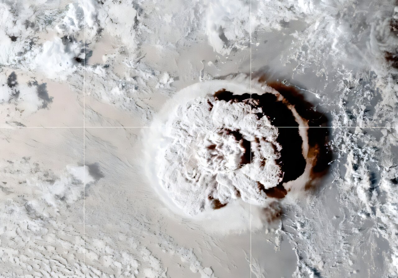
In January 2022, the Hunga Tonga–Hunga Haʻapai underwater volcano erupted with a fury that shook the planet. Its explosion—so powerful it shot a plume of ash 37 miles into the sky, the tallest eruption ever recorded by satellites—also sent a death sentence cascading down through the ocean layers. It wasn’t fire or lava that caused the devastation, but ash. Tons of it. A choking, suffocating wave of volcanic sediment that buried life on the seafloor and reshaped everything in its path.
Four months later, aboard a research cruise in the South Pacific, a young scientist named Marcus Chaknova, then an undergraduate at the University of Oregon, found something unexpected: a thick, silent carpet of volcanic ash covering the deep seabed like a shroud. It would become the centerpiece of a breakthrough scientific study—one that is not only revealing how undersea eruptions shape marine ecosystems, but also raising alarm about the future of deep-sea mining and the fragile life it could erase.
“This was an extremely rare opportunity,” says Chaknova, now a graduate student in earth sciences. “Observing the mass movement of underwater sediment is something that hasn’t been studied much—especially not on this scale.”
A Plume That Touched the Sky—and the Seafloor
The Hunga eruption was nothing short of historic. Not only did it blast through the ocean’s surface with the force of hundreds of Hiroshima bombs, it also generated tsunamis, broke underwater cables, and sent ripples through the Earth’s ionosphere. But what caught Chaknova’s attention wasn’t the drama above—it was the quiet devastation unfolding thousands of feet below.
The ash that settled on the ocean floor didn’t arrive all at once. Instead, it drifted downward over weeks, maybe even months, moved by ocean currents and shaped by underwater avalanches known as “density flows.” The particles ranged from smooth, rounded grains to jagged shards—some smaller than a human hair, others sharp enough to slice through the gills of filter-feeding creatures.
“In some places the deposit was very thick, like a meter to a meter and a half,” said Professor Thomas Giachetti, one of Chaknova’s mentors on the project. “Most of it is made of very fine grains, less than 100 microns. That’s about the size of one of your hairs.”
Back on land, Chaknova and his team traced the path of the ash, matching samples across vast distances. The eruption had left a footprint over 100 kilometers wide. Using computer simulations and chemical analyses, the researchers followed the sediment from the heart of the volcano’s shattered caldera all the way to distant coral reefs.
And what they found beneath the ash was sobering.
Suffocated in the Dark
The deep ocean is not dead. Far from it. It is a realm of strange and beautiful life forms that thrive in darkness, not by photosynthesis but through chemosynthesis—the process of converting methane, ammonia, and other chemicals from hydrothermal vents into usable energy.
But this deep-sea world is fragile. When a sudden blanket of ash covers the ocean floor, it doesn’t just inconvenience these organisms—it dooms them.
After the Hunga eruption, many organisms that lived near the seafloor were buried alive. Mobile creatures like worms and anemones tried to dig their way out but were overwhelmed. Sessile creatures—those anchored in place—were simply smothered.
“About 90% of marine organisms live on or near the seafloor,” Chaknova says. “A lot of them are suspension feeders. They catch tiny particles floating in the water to eat. But with all the sediment stirred up, they’re only grabbing ash. It clogs their gills, their intestines, and stops them from making energy.”
The damage didn’t stop in the deep. As the ash settled across the ocean, it triggered surface-level plankton blooms, but also choked coral reefs with sediment. In Tonga, where coral ecosystems are vital for fishing and tourism, this created a ripple effect.
What happens to the coral happens to the reef fish. What happens to the fish happens to the people.
“Fishing is incredibly important for the economic and food security of Tonga,” Chaknova explains. “This is not just about biodiversity—it’s about livelihoods.”
The Unseen Avalanche and the Race to Understand It
The sediment didn’t fall like snow. It moved like an underwater avalanche, crashing along the seafloor and carving canyons deep into the earth. The force was enough to snap fiber-optic cables, cutting communication lines and allowing scientists to measure the speed of the sediment flow based on when signals went dark.
“This wasn’t a slow drift,” Giachetti says. “It was a fast, high-energy surge that traveled with devastating power.”
Using advanced modeling, Chaknova is now working to map the full trajectory of that flow—something that has never been done at this scale in the ocean before. And while it started with a volcano, the implications go far beyond natural disasters.
Mining the Seafloor, Stirring Up Trouble
Buried under the seafloor, often in the form of potato-sized nodules, are immense deposits of precious metals—copper, cobalt, rare earth elements—vital for building the batteries and electronics that power a green future.
As demand for electric vehicles and renewable energy grows, mining companies are eyeing these underwater resources. Small island nations like Tonga, whose waters are rich in such minerals, are being approached with promises of economic windfalls. But scientists are concerned that stirring up these ancient deposits could unleash plumes of sediment as destructive as a volcanic eruption.
“This study gives us a real-world look at what happens when the seafloor is disturbed,” says Giachetti. “It’s not just dust settling back down—it’s an ecosystem being buried.”
The slow fall of sediment, the clogging of gills, the suffocation of deep-sea life—these aren’t just theoretical risks. They’ve already happened. And thanks to Chaknova’s research, we now have a glimpse of what that means for the planet.
A Scientific Effort Rooted in Respect
Despite being unable to visit Tonga during the height of the pandemic, Chaknova made sure that his research wasn’t just data extraction. He worked closely with local scientists like Taaniela Kula, head of the Tongan Geological Services, and ensured that all findings and samples were shared transparently.
He is also vocal about the need to avoid what he calls “parachute science”—a term for research conducted in developing nations by foreign scientists who fail to build lasting relationships or empower local communities.
“Developing an international scientific relationship is easy,” Chaknova says. “Maintaining that relationship after the research ends is much harder—but absolutely essential.”
Ashes and Warnings
The ocean holds stories in its silence. The story of the Hunga eruption is not just one of nature’s fury—it’s a warning. What happens when we disturb the ocean floor, whether by volcanic eruption or human industry, sends ripples through entire ecosystems.
Chaknova’s research, published in Geochemistry, Geophysics, Geosystems, may be the first step in understanding those ripples. It may also be the first warning shot in the looming debate over how—and whether—we mine the deep sea.
For now, the ash lies still at the bottom of the ocean. But what it buried, and what it revealed, may shape the future of marine science and conservation for decades to come.
Reference: Marcus Chaknova et al, How Did Westward Volcaniclastic Deposits Accumulate in the Deep Sea Following the January 2022 Eruption of Hunga Volcano?, Geochemistry, Geophysics, Geosystems (2025). DOI: 10.1029/2024GC011629
