Every day, billions of people open their smartphones, tap an app, and instantly know exactly where they are in the world. Whether you’re summoning a rideshare, finding the nearest coffee shop, or navigating the streets of a foreign city, you’re relying on something extraordinary: the Global Positioning System. GPS is so seamlessly integrated into modern life that most of us never stop to think about how it actually works.
But behind that little blue dot on your map is a marvel of modern physics—an elegant choreography of space, time, and electromagnetic waves. The accuracy of GPS hinges on Einstein’s theories of relativity, precise atomic clocks, and a constellation of satellites orbiting 20,000 kilometers above Earth. This isn’t just a story of engineering. It’s a tale of how abstract physics becomes practical magic.
Let’s dive into the deep mechanics of GPS and explore the physics that makes it all possible.
The Constellation Overhead
To understand GPS, we first need to look to the sky. Orbiting our planet at an altitude of approximately 20,200 kilometers are at least 24 operational GPS satellites at any given time, maintained by the United States Space Force. These satellites circle the Earth twice a day and are arranged in such a way that at least four of them are visible from any point on Earth at all times.
Each satellite continually broadcasts a signal that includes the time the message was sent and the satellite’s exact location in space. These are not just any time stamps—they are generated by atomic clocks onboard each satellite, which are accurate to within a few billionths of a second.
When your GPS receiver—whether in your phone, car, or smartwatch—picks up these signals, it uses the time delay between transmission and reception to calculate your distance from each satellite. By comparing signals from at least four satellites, the receiver determines your exact position through a method called trilateration.
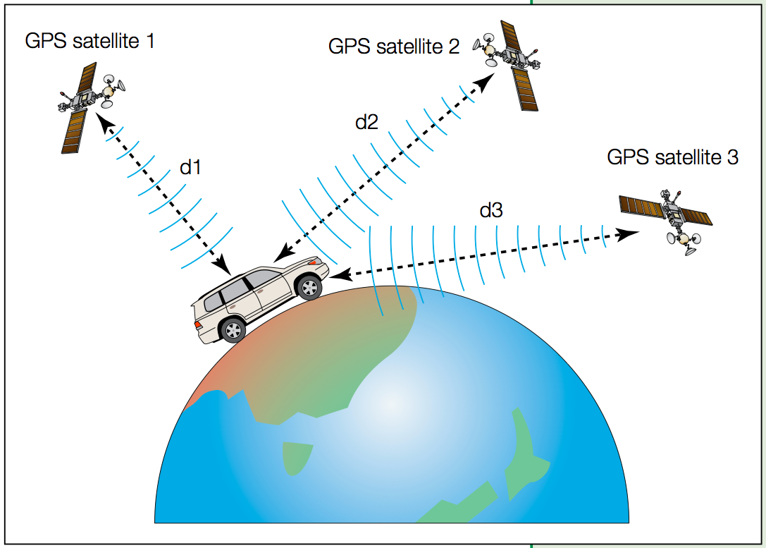
Trilateration: Finding You Through Geometry
The core principle of GPS positioning is trilateration, which, despite sounding complicated, is fundamentally based on simple geometry. If you know your distance from one satellite, you know you’re somewhere on the surface of a sphere centered on that satellite. If you add a second satellite, your location must lie on the circle where the two spheres intersect. With a third satellite, your position narrows down to two possible points. One of these is usually nonsensical—floating somewhere in space—so it can be eliminated. A fourth satellite helps correct for time discrepancies in your receiver’s clock, providing an exact fix.
The math gets more complex because the satellites are moving, your receiver is moving (if you’re driving or walking), and the signals travel through the atmosphere, which affects their speed. But at its heart, GPS relies on the geometry of spheres and the finite speed of light.
This leads us to the next crucial aspect: the speed at which GPS signals travel.
The Speed of Light and Signal Timing
The electromagnetic signals from GPS satellites travel at the speed of light—about 299,792 kilometers per second in a vacuum. Your receiver determines how far you are from a satellite by measuring how long it took the signal to arrive.
Since light travels about 300,000 kilometers per second, a delay of just one millisecond corresponds to a distance of 300 kilometers. That means even tiny timing errors can produce massive positional inaccuracies. If your receiver’s clock is off by even a microsecond (a millionth of a second), your position could be wrong by 300 meters.
To avoid this, GPS relies on extremely precise clocks—specifically, atomic clocks.
Atomic Clocks: The Heartbeat of GPS
Each GPS satellite carries multiple atomic clocks based on cesium or rubidium atoms. These clocks are accurate to about one nanosecond (a billionth of a second). Atomic clocks work by measuring the natural vibration frequency of atoms. In the case of cesium, the clock measures transitions between two energy states of the cesium-133 atom, which occur at a frequency of exactly 9,192,631,770 cycles per second.
Why are atomic clocks necessary? Because GPS positioning hinges on ultra-precise time measurements. Any error in timing translates directly into an error in distance. Atomic clocks keep time so accurately that their error over an entire day might be less than a millionth of a second, corresponding to a positional error of just a few centimeters.
But even atomic clocks aren’t perfect. And this is where Einstein enters the picture.
Relativity in Action: Time Dilation and GPS
Einstein’s theories of Special and General Relativity are not just theoretical curiosities. They’re vital to the functioning of GPS.
According to General Relativity, time runs faster in weaker gravitational fields. Since GPS satellites are far from Earth’s surface, they experience a weaker gravitational pull than you do. As a result, their clocks run faster—by about 45 microseconds per day.
Special Relativity, on the other hand, tells us that moving clocks tick more slowly. GPS satellites travel at around 14,000 kilometers per hour, which causes their clocks to slow down by about 7 microseconds per day.
The net effect is that satellite clocks gain approximately 38 microseconds per day compared to clocks on Earth. If these relativistic effects weren’t accounted for, GPS positions would drift by about 10 kilometers each day. That’s enough to render the entire system useless.
To correct for this, engineers pre-adjust the satellite clocks so they run slightly slower on the ground. Once in orbit, relativistic effects cause them to tick at just the right rate as seen from Earth.
In other words, every time you use your GPS, you’re using relativity. Einstein would be proud.
Signal Propagation: Through the Atmosphere
While satellite signals travel at the speed of light, they don’t move through empty space the entire time. They must pass through Earth’s atmosphere, which introduces errors.
The ionosphere, a region filled with charged particles, can cause the signal to bend and slow down, especially during solar storms or high sunspot activity. The troposphere, the lower part of the atmosphere, also affects signal speed depending on temperature, pressure, and humidity.
To correct these errors, modern GPS receivers use models of atmospheric conditions or dual-frequency techniques. Some satellites broadcast on two frequencies. By comparing how each frequency is affected by the atmosphere, the receiver can estimate and correct the delay.
Differential GPS and Precision Corrections
Even with all these corrections, standard GPS has an accuracy of about 5 to 10 meters. But many applications require even greater precision—agricultural equipment steering, drone operations, aircraft navigation, and autonomous vehicles all demand sub-meter or even centimeter-level accuracy.
That’s where systems like Differential GPS (DGPS) and Real-Time Kinematic (RTK) GPS come in. DGPS uses a network of fixed ground-based reference stations that know their exact location. These stations compare the known position with the GPS-determined position and broadcast correction data to nearby receivers.
RTK goes even further by using the phase of the GPS signal’s carrier wave, enabling centimeter-level precision. This level of accuracy is crucial for surveying, robotics, and precision farming.
The Role of Geodesy: Understanding the Shape of the Earth
GPS doesn’t just navigate the surface of the Earth—it helps define it. Geodesy, the science of measuring Earth’s shape, relies heavily on GPS. Earth is not a perfect sphere; it’s an oblate spheroid, slightly flattened at the poles and bulging at the equator. On top of that, the surface undulates with mountains, valleys, and tectonic shifts.
GPS helps scientists track plate movements, monitor sea-level rise, and study the effects of glacial melting. It provides data to refine our understanding of Earth’s shape and gravity field, improving everything from geological models to climate predictions.
GPS Beyond Earth: Deep Space and Other Planets
GPS has inspired similar systems for deep-space navigation. NASA has begun experimenting with XNAV—X-ray navigation using pulsars. These cosmic beacons emit incredibly regular signals that can be used like GPS satellites to navigate in space. In the future, spacecraft might carry atomic clocks and use timing signals from multiple sources to triangulate their position millions of kilometers from Earth.
The principles behind GPS—precise timing, signal analysis, relativistic corrections—will be just as relevant on Mars or the Moon as they are on Earth. The European Space Agency, China, Russia, and India are all working on their own global navigation satellite systems, like Galileo, GLONASS, and BeiDou, expanding the coverage and redundancy of satellite navigation.
Privacy, Security, and GPS Spoofing
GPS isn’t without its vulnerabilities. Because the signals are weak by the time they reach Earth’s surface, they’re susceptible to jamming—deliberate or accidental interference that prevents receivers from functioning. Even more concerning is spoofing, where false GPS signals are transmitted to deceive receivers.
Spoofing has been used to mislead ships, redirect drones, and even mask military activity. To counter this, governments and companies are developing encrypted GPS signals and multi-signal receivers that can detect inconsistencies.
Furthermore, the constant location tracking enabled by GPS raises questions about privacy and surveillance. While incredibly useful, GPS also allows for detailed data collection on individuals’ movements, requiring careful consideration of how that information is stored and used.
Everyday Magic: GPS in Our Lives
Despite its complexity, GPS feels like magic. It enables ride-hailing apps, turn-by-turn navigation, fitness tracking, asset monitoring, and emergency services. Farmers use it to guide tractors with centimeter precision. Surveyors map landscapes with millimeter accuracy. Pilots land aircraft in zero visibility. Hikers, bikers, and sailors trust it to keep them safe.
All this is possible because of precise physics, floating satellites, and the mathematical interplay of time and space. It’s a stunning example of how pure science—atomic theory, geometry, and relativity—has become integral to daily life.
Looking to the Future: The Evolution of Navigation
The future of GPS lies in augmentation and integration. Systems like Galileo (Europe), BeiDou (China), and GLONASS (Russia) complement and sometimes surpass traditional GPS in accuracy and reliability. The integration of multiple systems—called multi-GNSS—improves robustness, especially in urban canyons where buildings block signals.
In addition to satellite navigation, ground-based systems like LORAN and new quantum technologies promise even greater precision. Quantum clocks, gravitational sensors, and machine learning-enhanced receivers may one day offer navigation solutions that don’t rely solely on satellites.
And in the distant future, when humanity establishes colonies on other worlds, some form of extraterrestrial GPS will be a necessity. Whether using pulsars, orbiting beacons, or something we’ve yet to imagine, the basic principles will remain: signals, timing, geometry, and the relentless precision of physics.
Conclusion: The Invisible Threads That Guide Us
Every time you open a map on your phone, you’re participating in one of humanity’s greatest scientific achievements. You’re connected to a web of satellites in the sky, synchronized to atomic clocks, corrected by relativity, and interpreted through advanced geometry. What began as a military project during the Cold War has become an essential fabric of civilian life, guiding planes, parcels, and people.
The Global Positioning System is more than just a tool—it’s a living example of how abstract scientific theories can evolve into technologies that shape the world. It’s proof that the universe’s most elegant truths—about time, light, and space—are not confined to textbooks but pulse through your devices, helping you find your way.
So the next time you see that blue dot moving across your screen, take a moment to appreciate the incredible physics guiding it. You are, in a very real sense, navigating spacetime.