Global warming isn’t a uniform phenomenon. Though we often speak of Earth’s rising temperature in terms of a neat global average—1°C warmer, 2°C warmer—the reality is far messier, far more dramatic. In some places, climate change feels like a whisper. In others, it roars like a hurricane. From the rapidly thawing Arctic to the wind-scoured peaks of the Himalayas, the Earth is warming unevenly, and this unevenness carries consequences that ripple across continents.
What does it mean when some regions warm two to five times faster than others? When the tropical oceans, vast and mighty, show only muted responses to heat, while glaciers in mountain ranges melt at record speed? It means that adaptation—our lifeline in a changing climate—cannot be one-size-fits-all. It means that survival will hinge on regional precision, not broad approximations. It means that we must look closer, deeper, and finer than ever before.
But until recently, our best scientific tools—global climate models—could only offer a blurry view. With resolution scales between 100 to 200 kilometers, these models smoothed over the jagged topography of mountains, overlooked the microclimates of coastal zones, and barely glimpsed the narrow lifelines of small island nations.
Now, a team of visionary scientists has cracked open the future with a new clarity.
Rewriting the Climate Map with Unprecedented Precision
In a groundbreaking collaboration, researchers from the IBS Center for Climate Physics (ICCP) at Pusan National University in South Korea and the Alfred Wegener Institute, Helmholtz Center for Polar and Marine Research (AWI) in Germany, have ushered in a new era of climate modeling. Using two of South Korea’s most powerful supercomputers—Aleph and Guru—they’ve performed simulations that peer into the future at a scale fine enough to capture mountains, monsoons, and the heartbeat of the ocean.
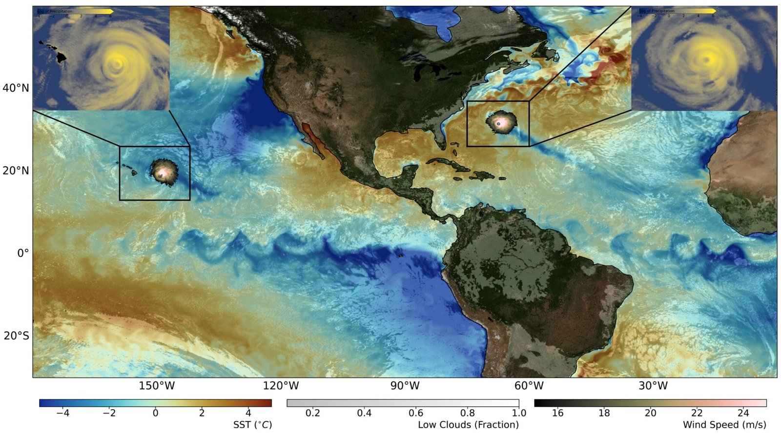
Their tool is the AWI-CM3 Earth system model—an advanced climate engine capable of simulating atmospheric processes at a stunning 9-kilometer resolution, and ocean currents between 4 and 25 kilometers. It’s like replacing a telescope with a microscope. For the first time, we can see Earth’s future climate not as a smooth, averaged surface, but as a rugged, breathing system, full of nuance, turbulence, and diversity.
The results, published in Earth System Dynamics, are as awe-inspiring as they are sobering.
The Pulse of a 1°C Warmer World
What happens to Earth when we warm the planet by just one more degree? The answer, it turns out, depends entirely on where you live. This high-resolution model doesn’t speak in generalities. It paints maps soaked in specificity, maps where winds shift, rains fall, oceans churn, and temperatures diverge dramatically.
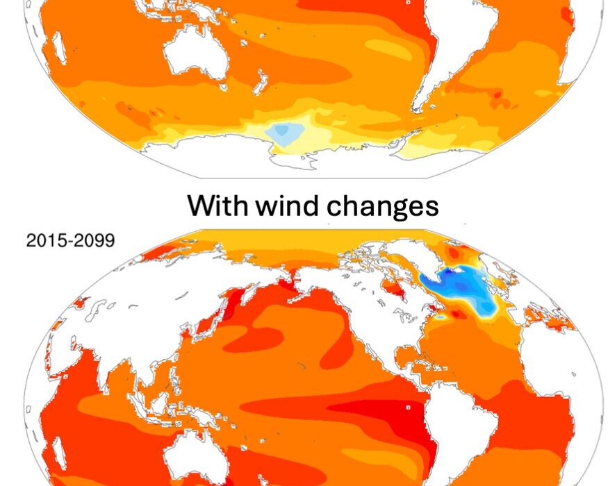
In the Canadian and Siberian Arctic, a 1°C increase in global temperature doesn’t mean 1°C locally—it means closer to 2°C. And over the Arctic Ocean? As much as 5°C. This is not a distant concern; it’s a climate rupture already visible in melting permafrost, vanishing sea ice, and changing migration patterns of polar wildlife.
High mountain regions—the Himalayas, the Andes, the Hindu Kush—are also heating up at an accelerated pace. The model shows these regions warming 45% to 60% faster than the global average. These places, known as “water towers of the world,” feed billions through glacial runoff and snowmelt. Their rapid warming threatens not just ice, but agriculture, drinking water, and energy security across Asia and South America.
For nations sitting in tropical zones or on island chains, the threat manifests differently. It’s not just about heat—it’s about rainfall, wind, storm behavior, and the subtle but deadly changes in ocean currents. These are changes that reshape coastlines, redefine fishing grounds, and redraw the very possibility of survival.
Where the Rains Come and Don’t Come
Rainfall—so often life’s lifeblood—becomes a double-edged sword in the climate future envisioned by AWI-CM3. This new model, with its fine-scale precision, reveals where rains will intensify and where droughts will dig in.
The simulations show that extreme rainfall events—those with more than 50 millimeters in a day—will increase in frequency and intensity across critical zones: eastern Asia, the slopes of the Andes, the green lungs of Amazonia, Africa’s mountain-tops, and even the eastern seaboard of North America. These aren’t just inconvenient rainstorms. They are floods, landslides, infrastructure failures, and crop destruction.
Meanwhile, other regions may experience the cruel irony of prolonged dry spells, where soil cracks open, aquifers dry, and food systems falter. In both extremes—too much water and too little—the common denominator is unpredictability, magnified by regional complexity.
A Climate Symphony Grows Louder
But beyond rain and temperature, the study also delves into the great oscillations of Earth’s climate—the slow, powerful rhythms that govern our weather systems. These include the Madden-Julian Oscillation (MJO), the North Atlantic Oscillation (NAO), and the El Niño-Southern Oscillation (ENSO), which together weave the fabric of seasonal patterns across the globe.
The AWI-CM3 model predicts a troubling amplification of these oscillations in a warmer world. El Niño and La Niña events—already known for their disruptive power—are projected to become more intense. This means stronger droughts in some regions, more destructive floods in others. The MJO, a traveling pulse of tropical rainstorms, will also grow more intense, bringing heavier rains to some areas and long dry periods to others.
These aren’t mere background processes. They are the bass notes of our climate, and they’re getting louder, more erratic, and harder to predict.
Island Nations on the Edge
The enhanced resolution of the AWI-CM3 model also brings long-overdue attention to Earth’s smallest and most vulnerable landscapes: the islands. Traditional global models have often treated small islands as mathematical noise—too small to resolve properly, too complex to simulate accurately.
But now, for the first time, entire island chains in the western Pacific are clearly visible in simulations. Their rainfall patterns, their susceptibility to storm surges, and their interaction with warming ocean currents are finally being quantified.
These islands, already facing the existential threat of sea level rise, now gain vital knowledge about how winds will shift above them, how storms will break upon their shores, and how much harder their futures might become. This data is more than academic—it’s a lifeline for planning, relocation, adaptation, and justice.
A Map for the Planners, a Tool for the Future
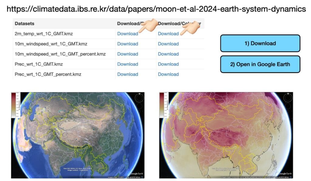
Recognizing the profound importance of these findings, the research team has made their data widely accessible through an interactive digital platform. Users—whether they’re city planners, farmers, engineers, or students—can explore projections of wind, rainfall, cloud cover, ocean currents, and more. These datasets, calibrated for a 1°C global warming scenario, are formatted for direct use with Google Earth, offering an immersive and intuitive way to visualize the future.
This isn’t just science—it’s empowerment. It allows governments to plan smarter, communities to prepare better, and individuals to understand more deeply the stakes they face.
As Prof. Axel Timmermann of the ICCP explains, the goal is not just to refine our understanding, but to democratize it. “Our new climate model simulations now provide regional insights into what these areas can expect… We hope that our dataset will be used extensively by planners, policy- and decision-makers, and the public.”
Seeing the Future to Shape It
Global climate change is the greatest challenge of our time, and for many, it remains an abstract threat—an idea too vast, too distant to fully grasp. But with this research, the future becomes visible. It becomes measurable. It becomes actionable.
The AWI-CM3 high-resolution simulations do not merely show us that the Earth is warming. They show us how, where, and why. They bring the storm into focus. They chart the path of the wind. They show a future that is not even—but still can be navigated, if we choose to understand it.
As the atmosphere thickens with greenhouse gases, as seas swell and glaciers retreat, this kind of clarity becomes our most powerful weapon. Against denial. Against delay. Against disaster.
In the end, the planet is not warming equally. But the urgency to act? That is universal.
Reference: Ja-Yeon Moon et al, Earth’s future climate and its variability simulated at 9 km global resolution, Earth System Dynamics (2025). DOI: 10.5194/esd-16-1103-2025