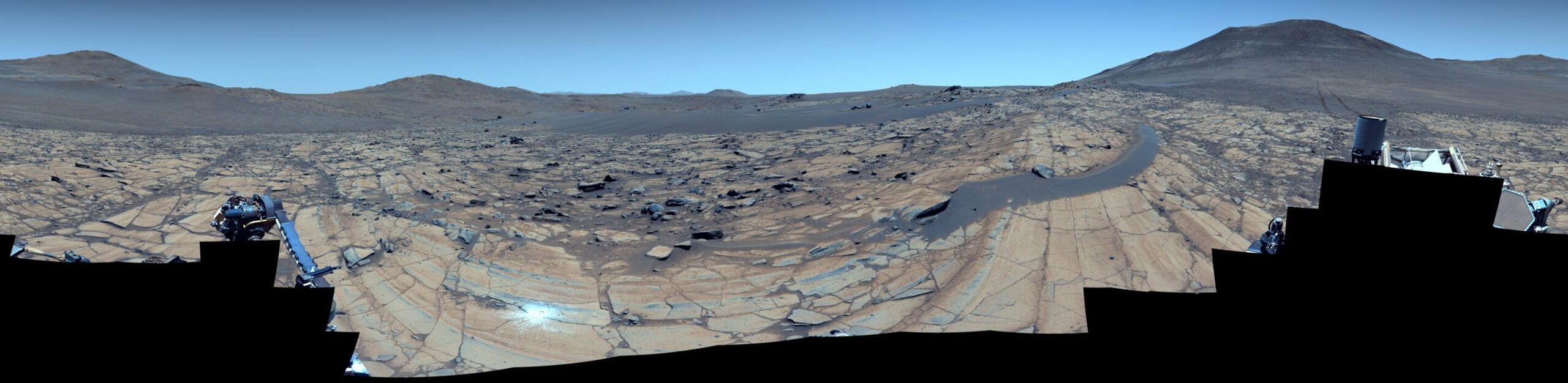
In an awe-inspiring glimpse of Mars’ deep geological past, NASA’s Perseverance rover has captured one of the most detailed panoramic views of its mission to date. Taken on May 26, 2025 (Sol 1516 of the mission), the stunning mosaic—stitched together from 96 high-resolution images—offers a breathtaking portrait of an alien world that once may have been shaped by water, wind, and time on a colossal scale.
The image, captured by Perseverance’s Mastcam-Z camera system, reveals the intricately layered terrain of a location known as “Falbreen,” located near the top rim of Jezero Crater. From rippled sands to ancient boulders and distant Martian hills that stretch as far as 40 miles (65 kilometers) away, the panorama isn’t just beautiful—it’s scientifically illuminating.
Blue Skies on a Red Planet
There’s something disarmingly Earth-like about the enhanced-color version of the image: the sky appears a soft blue, creating a surreal contrast with the ruddy Martian terrain. But this is not the sky one would see if standing there—it’s the result of color enhancements made by the imaging team to help emphasize subtle differences in rock and soil composition.
The natural-color version tells a different story: Mars returns to its signature crimson hue, its skies filled with fine dust that bathes everything in rusty light. This contrast between versions does more than appeal to the eye; it helps scientists distinguish geologic units and surface textures with greater precision.
“The relatively dust-free skies provide a clear view of the surrounding terrain,” said Jim Bell, principal investigator for Mastcam-Z at Arizona State University. “And in this particular mosaic, we’ve enhanced the color contrast, which accentuates the differences in the terrain and sky.”
A Floating Clue to the Past
At the heart of this mosaic is a curious rock—large, pale, and seemingly out of place. It rests delicately atop a crescent-shaped sand ripple, about 14 feet (4.4 meters) from the rover’s current position. To the untrained eye, it may look ordinary. But to planetary geologists, it’s a compelling puzzle.
This type of rock is what scientists call a “float rock”—a geologic wanderer, likely formed in a different location and transported to its current resting place. Its journey to Falbreen could have been the result of landslides, Martian floods, or the slow but persistent push of wind. The fact that it now sits atop a sand ripple suggests that it arrived before the ripple formed—a tantalizing clue about the sequence of geologic events that shaped this region.
This small but striking detail underscores the power of Perseverance’s camera suite. These aren’t just snapshots; they are scientific documents, helping researchers reconstruct the history of a planet billions of years old.
Scratching the Surface—Literally
Just below the center of the image, another bright feature catches the eye: a small white circle, about two inches (five centimeters) in diameter. This is not a natural formation, but the result of human hands—more specifically, the rover’s robotic arm.
Known as an abrasion patch, this shallow circle is the 43rd such mark made by Perseverance since it touched down on Mars in February 2021. Created using the rover’s drill, it scrapes away the top layer of weathered, dusty rock to expose the fresher material beneath. This allows the science team to study a rock’s true composition before deciding whether it’s a worthy candidate for core sampling.
The abrasion was made on May 22, and just two days later, the rover’s suite of instruments began proximity science—close-up analyses of Martian rock and soil chemistry. Every detail matters here, because Falbreen might be the oldest terrain Perseverance has yet explored. That includes Jezero Crater itself, which once hosted a lake and is believed to have been shaped by ancient river systems.
What lies beneath that dusty surface could hold key clues to Mars’ early history—and perhaps even evidence of past microbial life.
A Journey Through Time—Marked in Rock
One of the most scientifically significant features of the panorama is the sharp, sweeping boundary line between two very different types of rock formations. It runs horizontally through the mosaic, delineating a stark transition from lighter-toned rocks closer to the rover to darker, more distant ones.
This line isn’t just a visual shift—it’s a geologic contact, the interface between two separate rock units. The flat, pale rocks are rich in olivine, a mineral that forms under volcanic conditions and is commonly found in planetary mantles, including Earth’s. In contrast, the darker, more rugged rocks beyond are believed to be older clay-bearing formations, possibly laid down in the presence of water.
For scientists, this boundary is a window into a dramatic planetary transformation. The olivine-rich rocks suggest a fiery volcanic past, while the clay-bearing rocks may preserve signs of an ancient, wetter Mars—a time when rivers flowed and lakes filled the Jezero basin.
Each mineral, each fracture, each change in texture is like a page in a very old, very dusty book. And Perseverance is slowly turning the pages.
Rover Tracks and the Path Ahead
Toward the right edge of the mosaic, faint wheel tracks fade into the distance. These are the marks of Perseverance’s journey, leading back to a site the science team has named “Kenmore.” From there, the rover made its way across roughly 300 feet (90 meters) of Martian surface to arrive at Falbreen—an intentional trek to reach what could be some of the most scientifically rich terrain on the planet.
The tracks serve as a quiet testimony to the rover’s persistence, and to the tireless work of mission planners back on Earth. Every maneuver, every pixel in the image, is the result of decades of engineering and months of planning. Mars may be a desolate place, but it’s one now touched by the careful, curious hands of human intellect.
Looking Beyond Jezero: The Human Horizon
The images from Falbreen are more than a scientific milestone—they are a prelude to the next great leap in space exploration. NASA officials, including Acting Administrator Sean Duffy, have been quick to link the rover’s achievements to the agency’s broader ambitions.
“Our bold push for human space exploration will send astronauts back to the Moon,” Duffy said. “Stunning vistas like that of Falbreen, captured by our Perseverance rover, are just a glimpse of what we’ll soon witness with our own eyes. NASA’s groundbreaking missions, starting with Artemis, will propel our unstoppable journey to take human space exploration to the Martian surface.”
Perseverance is not just paving the way for science—it’s laying the groundwork for future explorers. The terrain it maps, the hazards it navigates, and the atmosphere it studies are all essential data for planning eventual human missions to Mars.
A Silent Witness in a Distant World
Perseverance, like its predecessors, is a marvel of engineering. But it’s also a silent, mechanical storyteller, sending home dispatches from a place no human has yet stood. In the absence of a heartbeat or a voice, it tells its story through images—through the sweep of a Martian horizon, the curve of a sand ripple, and the shimmering line of a geologic contact.
Each image it sends back is more than just data. It’s a reminder of what’s possible when curiosity meets courage, and when science is driven not just by the need to know, but by the need to understand.
From the float rocks that whisper of past landscapes, to the clay beds that might once have cradled life, Falbreen is not just a Martian outcrop—it’s a chapter in a story that spans planets, epochs, and the ever-expanding human imagination.
And Perseverance is still writing it.