It often starts in silence. A whisper beneath the ground. A swelling pressure under the sea. A dark swirl forming in the sky. Nature rarely shouts its intentions. Yet within that quiet, there are signals—small, fleeting warnings—that the planet is about to shift, erupt, flood, or rage.
Every year, natural disasters impact millions of lives. Earthquakes level cities. Hurricanes flood entire coastlines. Volcanic eruptions turn day into night. Tornadoes tear through towns with terrifying speed. Wildfires, landslides, droughts, tsunamis—all reminders that this planet, as beautiful and generous as it is, is also in motion. And when it moves, it does not ask for permission.
But what if we could hear Earth before it roars? What if we could listen to the rumbles, read the clouds, detect the slightest change in ocean currents, or the tremor of a fault line about to awaken?
This is where Earth science steps in—not as a crystal ball, but as a discipline of deep listening. Geologists, seismologists, meteorologists, hydrologists, oceanographers, and remote sensing experts come together with one common goal: to understand Earth well enough to predict its most dangerous moods.
This is the story of how Earth science is learning to predict the unpredictable—and save lives in the process.
The Science of Reading Earth’s Warnings
Predicting natural disasters is not like forecasting a date in the future with pinpoint precision. It’s more like anticipating a fire by studying smoke, or hearing the faintest beat of a drum before a storm begins. Earth rarely offers simple warnings. But it always leaves clues.
Earth science uses a vast range of data—satellite imagery, seismic readings, atmospheric pressure patterns, river flow measurements, radar scans, and historical records—to recognize these clues. Every field has its own tools, its own language of signs.
When a volcano swells by a few centimeters, volcanologists raise their eyebrows. When sea temperatures rise unexpectedly in the Pacific, meteorologists know that El Niño might be approaching. When the ground shakes in a familiar rhythm, seismologists pay attention to patterns that hint at something more ominous. When rainfall exceeds expected thresholds on already saturated hills, hydrologists prepare for possible landslides.
The central aim of Earth science in disaster prediction is not just to understand how nature works, but to detect when it is about to change in ways that threaten human life.
Earthquakes: The Unpredictable Giants
Of all natural disasters, earthquakes are among the most feared—and the most difficult to predict. They strike without warning, often within seconds. In 2010, Haiti experienced a devastating magnitude 7.0 quake near its capital, killing over 200,000 people. No one saw it coming. That kind of sudden destruction has haunted seismologists for decades.
Earthquakes originate when tectonic plates—massive slabs of Earth’s crust—grind past each other or collide. Stress builds along faults over years, decades, even centuries, until suddenly, it is released in a violent rupture. The energy radiates outward as seismic waves, shaking the ground and everything on it.
Predicting when a fault will rupture is nearly impossible with current science. But researchers are making progress in identifying which areas are at risk—and what the early signs of seismic activity might be. By mapping historical quake patterns and measuring stress accumulation in the crust using GPS and InSAR (satellite radar), scientists can forecast the probability of future earthquakes in specific zones.
Some experimental systems are even trying to detect the seconds before a quake hits. In countries like Japan, early warning systems based on networks of seismometers can sense the first waves of an earthquake—the P-waves—before the more destructive S-waves arrive. This can give people a few precious seconds to take cover, halt trains, or shut down gas lines.
Though we’re still far from fully predicting earthquakes, Earth science is providing the foundations for early warnings and risk mitigation—one data point at a time.
Volcanoes: Fiery Mountains with Voices
Unlike earthquakes, volcanoes often give off clear warning signs before they erupt. And in many cases, Earth scientists have become adept at listening to those warnings.
A volcano is not just a mountain; it’s a breathing, restless system. Before it erupts, it often swells as magma pushes upward. Seismic activity increases beneath its surface. Gases like sulfur dioxide escape through cracks. Temperatures near vents rise. All these signs are monitored by volcanologists through ground-based sensors and satellite instruments.
One of the most remarkable recent examples of volcano monitoring in action occurred in Iceland in 2010. The Eyjafjallajökull volcano, which had been quiet for nearly 200 years, began rumbling months before it erupted. Scientists noticed increased earthquakes under the mountain and slight surface inflation. When the eruption finally came, it spewed ash so high into the atmosphere that it disrupted air travel across Europe. But thanks to the monitoring systems in place, authorities were able to issue timely warnings and prevent casualties.
Across the globe, volcano observatories use a combination of seismic networks, thermal cameras, satellite imagery, gas sensors, and drone surveillance to monitor active and dormant volcanoes. While predicting the exact moment of eruption remains difficult, forecasting weeks or days ahead has become more accurate—an impressive achievement made possible by Earth science.
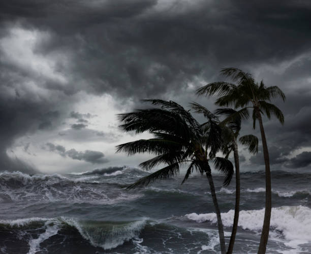
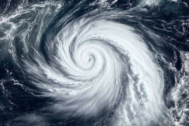
Storms from the Sky: Hurricanes, Cyclones, and Typhoons
No spectacle in nature is as awe-inspiring and terrifying as a fully formed hurricane swirling over the ocean, its eye eerily calm, its arms spinning with deadly intent. These storms—called hurricanes in the Atlantic, cyclones in the Indian Ocean, and typhoons in the Pacific—are among the most destructive natural events on Earth.
But they are also among the most successfully predicted.
Meteorologists track the birth of hurricanes from the moment a cluster of thunderstorms begins to organize over warm tropical waters. Satellites scan for the distinctive spiral shape, while aircraft fly directly into developing storms to gather wind speed and pressure data. Computer models take that data and simulate the storm’s potential path, intensity, and landfall.
In 2005, Hurricane Katrina slammed into the Gulf Coast of the United States. While the storm caused catastrophic damage, forecasters had predicted its arrival days in advance. This early warning allowed for partial evacuations and emergency preparations that saved many lives.
Modern hurricane prediction relies heavily on Earth science’s ability to model atmospheric behavior. Advanced weather models like the ECMWF and GFS use ocean temperatures, wind shear, air pressure, and humidity levels to simulate storm evolution. As computing power increases, these models have become more accurate, offering crucial insights into where a storm will hit and how strong it will be.
Still, challenges remain—especially in predicting sudden intensification or changes in track. But the ability to issue alerts days ahead of impact has revolutionized disaster preparedness.
Tsunamis: The Silent Killers
There is something uniquely cruel about tsunamis. They often follow another disaster—usually an earthquake—and arrive with terrifying speed, destroying everything in their path.
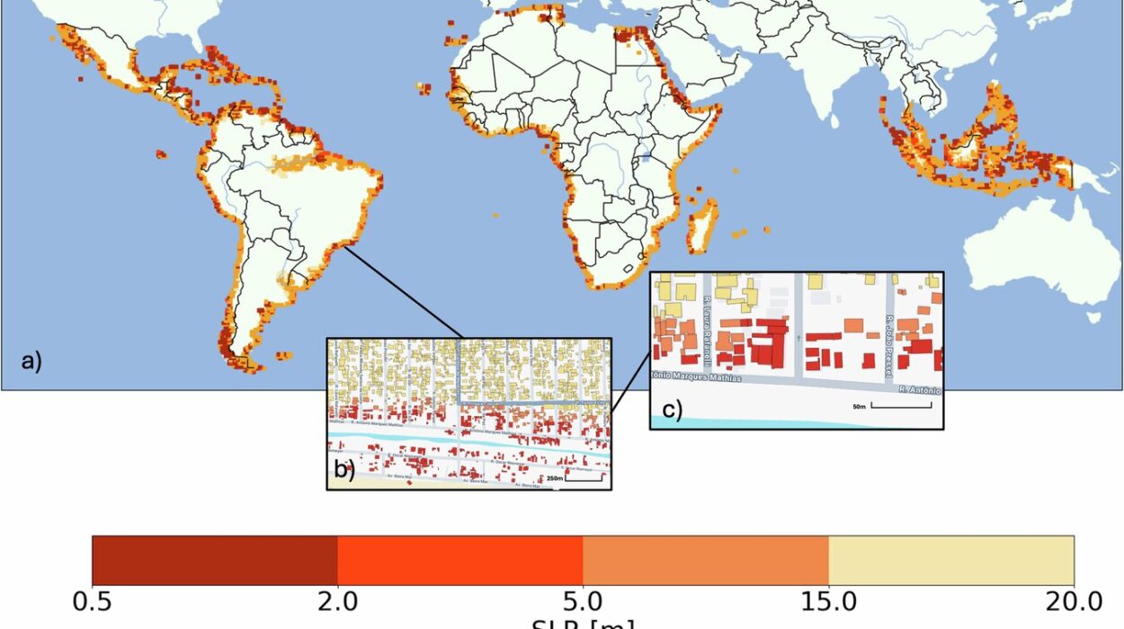
In 2004, a massive undersea earthquake off the coast of Sumatra triggered a tsunami that swept across the Indian Ocean, killing more than 230,000 people in 14 countries. It was one of the deadliest natural disasters in recorded history—and it revealed just how little warning systems had been developed for tsunamis.
Since then, tsunami prediction has become a major focus for Earth scientists. Undersea pressure sensors, buoys, and coastal tide gauges now form global networks that can detect tsunami waves within minutes of an undersea quake. When a quake occurs, algorithms analyze its location, depth, and magnitude to determine whether a tsunami is likely.
If a threat is confirmed, alerts can be issued to coastal populations using sirens, text messages, and emergency broadcasts. In Japan, for instance, citizens receive tsunami warnings on their phones within seconds of an offshore quake.
Earth science has also helped identify the geological zones most prone to tsunami generation—such as subduction zones where tectonic plates collide. This allows coastal planning and infrastructure to account for the risk, reducing long-term vulnerability.
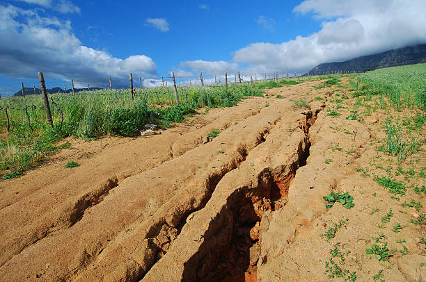
Landslides and Floods: Watching the Ground Give Way
When the ground itself begins to move—not from below, but from above—it can be just as deadly. Landslides and floods are often sudden and devastating, especially in mountainous or densely populated regions.
Earth scientists predict these disasters by monitoring rainfall, soil moisture, slope stability, and river flow. In landslide-prone areas, ground-based sensors detect soil movement, while satellites like NASA’s Landsat series track long-term changes in vegetation and land cover.
In flood forecasting, real-time rainfall data is crucial. Doppler radar systems track storm intensity, while stream gauges measure river levels. Hydrologists combine this information with computer models to predict when and where flooding is likely to occur. The European Flood Awareness System and the U.S. National Water Model are examples of advanced platforms that provide early warnings.
In some regions, scientists are even using machine learning to improve prediction by analyzing past events and correlating them with environmental triggers.
Wildfires: Blazes on the Wind
As climate change increases global temperatures, wildfires have become more frequent and intense. Predicting when and where they will ignite is difficult, but Earth science plays a vital role in understanding fire behavior and risk.
Remote sensing satellites detect hotspots—areas where ground temperatures suddenly spike—while weather data helps predict fire spread. Drought indices, wind patterns, humidity levels, and fuel conditions are all factors in wildfire forecasting.
In California, for example, the state uses a system called FPI (Fire Potential Index) that assesses the likelihood of wildfire outbreaks using satellite and meteorological data. When conditions reach critical thresholds, alerts are issued to fire agencies and the public.
New technologies, including AI-driven fire models and drones equipped with thermal sensors, are pushing the frontier of wildfire prediction. While we may not always stop fires from starting, knowing where they’re most likely to erupt helps prepare and protect communities.
The Role of Technology: Satellites, Sensors, and Supercomputers
None of these predictive systems would be possible without the technological tools that Earth science now depends on. Satellites orbiting Earth scan every corner of the planet, capturing data on weather systems, ocean temperatures, land deformation, and more. Seismometers embedded in the crust pick up vibrations from deep within the Earth. Radar and LIDAR create high-resolution maps of terrain changes. And supercomputers process this torrent of information to simulate disaster scenarios.
These technologies have transformed disaster prediction from guesswork to informed science. NASA, NOAA, the European Space Agency, and countless national agencies collaborate on gathering and sharing data that helps forecast disasters more accurately than ever before.
A Global Effort for a Safer Future
Disasters do not respect borders. A tsunami that begins in Indonesia can strike Kenya. A hurricane that forms in the Atlantic can cross into Mexico. Earth science, therefore, must be global.
International collaborations—like the Pacific Tsunami Warning Center, the Global Earthquake Model Foundation, and the World Meteorological Organization—share data, resources, and strategies across nations. These efforts reflect a growing understanding: that in order to survive on a dynamic planet, humanity must learn together.
Earth science is not just about prediction—it’s about resilience. It’s about building better cities, reinforcing coastlines, educating populations, and preparing emergency responders. Prediction buys time. Preparedness saves lives.
Listening to Earth’s Secrets
The Earth is speaking. Not in words, but in waves, winds, shifts, and signals. It tells us when its pressure is building, when its clouds are gathering, when its waters are rising. It has always spoken this way.
What has changed is our ability to listen.
Earth science gives us the ears to hear, the eyes to see, and the minds to understand what this planet is trying to tell us. It turns raw data into life-saving forecasts. It transforms ancient fears into modern readiness. It brings together science, technology, and compassion in a mission to protect life from nature’s fiercest forces.
We cannot prevent natural disasters. But we can prepare for them. We can read the signs in the sky and the sea, in the soil and the shaking ground. We can listen more carefully than ever before.
Because in the silence before the storm, in the swell before the wave, in the stillness before the quake—Earth is whispering.
And science is finally learning how to answer.