For as long as humans have lived on Earth, natural disasters have haunted our imaginations and ravaged our civilizations. We find their echoes in ancient myths—the earth-shattering anger of Poseidon, the fiery wrath of volcanic gods, the cleansing fury of floods sent by the heavens. Long before we had the language of plate tectonics or atmospheric pressure, we watched the sky and the ground with trembling awe, praying for signs, sacrificing to unseen forces, and running when the ground cracked beneath our feet.
But superstition, however comforting or terrifying, was never enough. As civilizations matured, so did our hunger to understand the very earth that betrayed us. And now, in the age of satellites, seismometers, and supercomputers, a question as old as civilization demands a modern answer: can we predict natural disasters?
Earthquakes: The Unpredictable Beasts Beneath
No disaster inspires as much helplessness as an earthquake. The ground, our constant companion and presumed foundation, suddenly turns to liquid or shudders with primal violence. Entire cities vanish in seconds. Lives are shattered. And the most frustrating part? Even today, earthquakes remain among the least predictable of natural disasters.
This isn’t for lack of trying. Across the globe, scientists monitor fault lines, measure ground strain, and track seismic activity with increasing precision. Yet despite all this, they still can’t say exactly when or where an earthquake will strike.
The reason lies in the chaotic nature of fault systems. Earthquakes occur when stress builds up between tectonic plates and is suddenly released. While we can measure stress and strain, we don’t yet fully understand what triggers the final snap. Sometimes, stress builds quietly for decades before release. Sometimes, smaller quakes relieve pressure. Other times, they are harbingers of something worse.
California’s infamous San Andreas Fault is a prime example. Scientists know it’s locked and loaded, that pressure is building, and that a major quake is inevitable. But “when” remains maddeningly elusive. The best we can currently do is probabilistic forecasting: for instance, stating there’s a 70% chance of a magnitude 7 or higher quake in the next 30 years. It’s useful for urban planning and emergency preparedness but cold comfort for people trying to live their lives.
Despite decades of research, the Earth refuses to give up her deepest secrets. Earthquake prediction remains a puzzle without a clear solution—but not without hope. Advances in AI and machine learning are beginning to comb through massive datasets for patterns invisible to the human eye. One day, perhaps, the Earth’s subtle signals will become readable.
Volcanoes: Fiery Mountains with a Voice
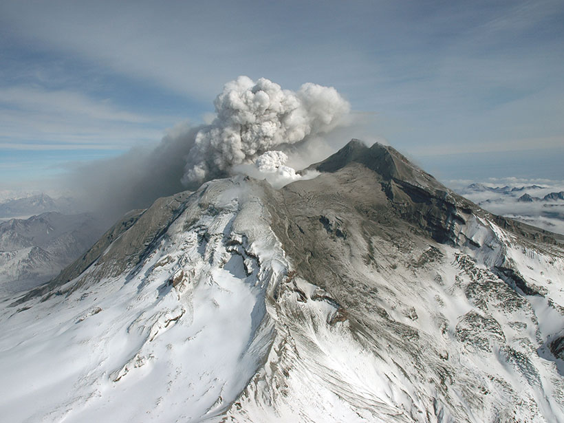
In contrast to earthquakes, volcanoes are somewhat more cooperative when it comes to predictions. Before an eruption, they usually send out warning signs: swelling of the ground, increased gas emissions, changes in temperature, and, most notably, tremors known as harmonic earthquakes that signal magma is on the move.
Scientists today can often forecast a volcanic eruption days, sometimes even weeks, in advance. Mount Pinatubo’s 1991 eruption in the Philippines, one of the most powerful in the 20th century, is a shining example of successful early warning. Thanks to a combination of seismic readings, gas measurements, and satellite imagery, scientists were able to evacuate tens of thousands of people, saving countless lives.
Still, volcanoes are far from fully predictable. Some erupt with little warning. Others rumble ominously for months without producing an eruption. The challenge lies in understanding not just the signs, but their context. One volcano’s typical behavior may be another’s death knell.
Even more troubling are the so-called “supervolcanoes” like Yellowstone. These giants hold enough magma to change the global climate, yet their behavior is slow, complex, and poorly understood. The idea of predicting such an eruption is tantalizing but remains mostly theoretical.
Volcanology, however, is advancing fast. Drones now monitor dangerous volcanoes up close. Infrared satellites scan for heat signatures. Networks of seismometers listen to the Earth’s belly like a stethoscope. Each tool brings us closer to reading the language of magma.
Hurricanes: The Monsters We Can See Coming
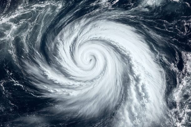
When it comes to hurricanes, we’ve made extraordinary progress in prediction. Thanks to decades of atmospheric research and a vast network of satellites, radar systems, and weather balloons, we can now track tropical cyclones from birth to landfall with impressive accuracy.
Meteorologists can often forecast the path of a hurricane several days in advance, giving people precious time to evacuate. Improvements in computer modeling allow for better predictions of storm intensity, though this remains more difficult than tracking direction.
Why? Because hurricane strength depends on complex interactions between ocean temperature, wind shear, and atmospheric moisture. Small changes in any of these can dramatically alter a storm’s behavior. Rapid intensification—where a storm suddenly grows much stronger in a short time—is particularly hard to predict and extremely dangerous.
Still, the difference between now and a few decades ago is staggering. In the 1970s, we might have had 12 hours’ warning before a major storm. Today, we often have 72 hours or more. It’s a triumph of Earth science, technology, and international cooperation.
Yet with climate change, hurricanes are growing stronger, wetter, and slower. These changes introduce new variables into our models. Predicting the behavior of a supercharged atmosphere is an ongoing scientific challenge, one we must meet with urgency.
Tsunamis: The Aftershocks of Silence
Few disasters are as terrifying as a tsunami. Often triggered by undersea earthquakes, landslides, or volcanic eruptions, tsunamis can cross entire oceans in a matter of hours. The 2004 Indian Ocean tsunami, which killed over 230,000 people, was a wake-up call for the world. It was not the first, but it reminded us how deadly these waves could be—and how little warning people had.
Since then, tsunami detection has improved dramatically. Networks of deep-ocean buoys now monitor changes in sea level and relay data in real time. Seismic networks detect undersea earthquakes and feed information to tsunami warning centers.
If an earthquake strikes in the Pacific, for example, scientists can usually estimate the risk of a tsunami within minutes. Automated alerts go out via radio, television, text messages, and sirens. In many places, evacuation plans are in place. In the United States, Japan, and Indonesia, drills are regularly held to keep people prepared.
However, “local tsunamis” pose a greater challenge. These are waves generated so close to the shore that they strike within minutes—too fast for distant warning systems to help. In such cases, education is key. People who live near coasts are taught to recognize natural warning signs: a strong earthquake, a sudden retreat of water, or an eerie silence. When the sea vanishes, run.
The science of tsunami prediction is improving, but geography still limits our reach. Earth doesn’t always give us time.
Floods and Landslides: Predictable, but Complex
Unlike earthquakes or tsunamis, floods and landslides are more tied to weather, terrain, and human behavior. Because of this, they are often more predictable—at least in theory.
Rainfall, snowmelt, soil saturation, and topography can all be measured and modeled. Meteorologists can forecast when and where heavy rain will fall. Hydrologists can estimate when rivers will overflow. Engineers can design levees and dams to hold back water.
Despite all this, flooding remains one of the most destructive disasters on Earth. Why?
Because prediction is only part of the equation. Implementation is everything.
Urban development often ignores flood risk. Wetlands that once absorbed rainwater are paved over. Drainage systems are overwhelmed. In some cases, people live in floodplains out of economic necessity or poor planning. Even when forecasts are accurate, evacuation orders may be ignored—or may never come.
Landslides, like floods, are tied to rainfall, geology, and vegetation. Scientists use a combination of slope analysis, rainfall thresholds, and ground sensors to estimate landslide risk. But like earthquakes, they’re triggered by sudden shifts that aren’t always obvious.
Both disasters are highly local in nature, making them harder to model globally. What works for one valley or mountain might fail in another. But the tools are getting better, and with the rise of remote sensing and machine learning, real-time landslide prediction is becoming more feasible than ever before.
Wildfires: The Heat Is Rising
In the past, wildfires were a seasonal threat in certain parts of the world. Today, they’re a global menace. Fueled by drought, heat, and wind, fires now rage in forests, grasslands, suburbs, and even arctic tundra. Climate change has extended fire seasons and intensified their ferocity.
Fortunately, wildfires are among the most predictable disasters in terms of risk. We know where conditions are ripe. Satellite imagery, weather models, and vegetation analysis allow scientists to identify fire-prone areas weeks in advance.
Short-term predictions are improving too. Fire spread models can now simulate how a blaze will grow based on wind speed, humidity, fuel type, and topography. In places like California and Australia, fire warnings are issued with color-coded risk levels, helping communities prepare and respond.
Still, wildfires remain dangerous because they evolve so quickly. A blaze that seems under control can explode into a firestorm with little warning. Embers carried by wind can start new fires miles away. And firefighting resources are often stretched thin.
Predicting a fire’s outbreak is still difficult. Most are started by lightning or human activity—campfires, cigarettes, power lines. Education, prevention, and rapid response are as important as prediction.
The Promise and Limits of Earth Science
Modern Earth science has brought us a long way. We’ve moved from rituals and guesses to sensors and simulations. We can model atmospheric circulation, track shifting plates, map underground magma chambers, and simulate river overflow with astonishing precision.
Yet even now, our forecasts remain probabilistic, not prophetic. We can say where disasters are likely, how severe they might be, and when they might occur. But certainty remains elusive.
The Earth is a dynamic, nonlinear system. It reacts to countless variables—many of which we still don’t understand. Chaos theory reminds us that tiny changes can lead to massive effects. That makes precise, long-term prediction incredibly difficult.
Still, the gap is closing. Advances in AI, big data, and remote sensing are enabling us to make better use of the information we already have. Predictive systems are learning to spot anomalies, flag risks, and even generate automated early warnings. The next frontier may lie in teaching machines to understand the Earth better than we ever could alone.
Climate Change: The Disaster Multiplier
No discussion of natural disaster prediction is complete without addressing climate change. It is not a disaster in the traditional sense, but a slow-motion crisis that amplifies all others.
Warming oceans fuel stronger hurricanes. Rising seas worsen coastal floods. Melting glaciers destabilize mountains. Drought makes wildfires and dust storms more intense. Climate change takes predictable disasters and adds new dimensions of uncertainty and danger.
This adds an urgency to Earth science. Prediction is no longer just about science—it’s about survival. It’s about giving people time to escape, to adapt, to prepare. It’s about protecting infrastructure, economies, and entire ways of life.
Climate models are improving, and so are disaster mitigation strategies. But the window to act is narrowing. The better we understand the Earth’s signals, the better chance we have to avoid catastrophe—not just tomorrow, but for generations.
The Human Element: Preparation, Not Just Prediction
Prediction, no matter how advanced, is meaningless without action. The greatest early warning system in the world is useless if governments ignore it, or if people have nowhere to go.
History shows this again and again. In 2005, Hurricane Katrina struck New Orleans with devastating force—but the storm itself was well forecasted. The tragedy lay not in prediction failure, but in human failure: poor infrastructure, ignored warnings, inadequate evacuation plans.
The same pattern repeats in earthquakes, floods, fires. Disasters are not “natural” in the way we often think. They are events amplified—or mitigated—by human choices.
To truly harness the power of Earth science, we must pair prediction with education, planning, and empathy. We must ensure that knowledge reaches the most vulnerable. Technology can warn, but only humans can prepare.
Conclusion: Reading the Earth’s Pulse
Can we predict natural disasters?
The honest answer is: sometimes, and we’re getting better. In some cases, like hurricanes and volcanic eruptions, our tools are incredibly powerful. In others, like earthquakes and landslides, we’re still listening for whispers beneath the chaos. But the trend is clear—we are learning to read the Earth’s pulse.
With every tremor, every storm, every flood, we gather more data. With every breakthrough in physics, geology, and computer science, we come a step closer to clarity. The Earth may never speak in perfect clarity, but we are finally beginning to understand her language.
The challenge now is not just to predict, but to act. The future of disaster science lies not only in technology, but in wisdom—and in the collective will to use both to protect what we hold dear.